IMAGES TAKEN NEAR TO
Old Mill Close, NOTTINGHAM, NG6 8TA
Introduction
This page details the photographs taken nearby to Old Mill Close, NG6 8TA by members of the Geograph project.
The Geograph project started in 2005 with the aim of publishing, organising and preserving representative images for every square kilometre of Great Britain, Ireland and the Isle of Man.

There are currently over 7.5m images from over14,400 individuals and you can help contribute to the project by visiting https://www.geograph.org.uk
Image Map
Images are licensed for reuse under creativecommons.org/licenses/by-sa/2.0
Notes
- Clicking on the map will re-center to the selected point.
- The higher the marker number, the further away the image location is from the centre of the postcode.
Image Listing (75 Images Found)
Images are licensed for reuse under creativecommons.org/licenses/by-sa/2.0
Image
Details
Distance
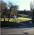
1
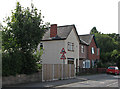
Moor Road, Bestwood
This is the meeting point of three local authorities, the actual point being in the middle of the road opposite the boundary marker to the right of the picture. The foreground is in the City of Nottingham, beyond, the centre line of the road is the boundary between Ashfield District (left) and Gedling Borough (right). The boundary marker http://www.geograph.org.uk/photo/3938689 was installed by the then Borough of Nottingham in 1877. The low wall beyond the boundary marker is the remains of the abutment of the railway bridge that crossed the road at this point; it carried the Midland Railway branch into Bestwood Colliery.
Image: © Alan Murray-Rust
Taken: 16 Apr 2014
0.04 miles
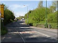
2
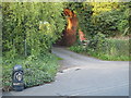
Nottingham, NG6 - Bestwood
"The Robin Hood Trail" crosses the B683 (the Hucknall Rd/Moor Bridge - Papplewick road) from the Bestwood Lane end of Mill Lane here and enters its "Leen Valley Walk" section via this ramped footpath ahead.
Image: © David Hallam-Jones
Taken: 17 Nov 2012
0.04 miles
3
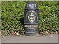
Boundary Marker, Bestwood
The most northerly point of the City of Nottingham. See also http://www.geograph.org.uk/photo/3938685
Image: © Alan Murray-Rust
Taken: 16 Apr 2014
0.04 miles
4
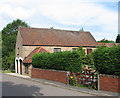
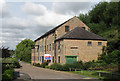
Bestwood: mill conversion
There was an iron foundry at Bestwood early in the 17th century, and a cotton mill was opened in the 1780s (see Image]). This stone-and-pantile building is now a home.
Image: © John Sutton
Taken: 13 Jul 2011
0.04 miles
5
Nottingham - NG6 (Bestwood)
This turning off Bestwood Road (the B683), as one proceeds in the direction of Hucknall Road (the A611), passes under a former railway line. Nowadays the bridge carries a nature trail across this farm track ahead allowing walkers and cyclists to join the Robin Hood Trail nearer to Bestwood Village. An imaginary inverted U shaped loop encapsulates this boundary marker, tying it - and this stretch of the B683 - into the administrative jurisdiction of Nottingham City Council. The photograph was taken from a spot that lies within Ashfield Borough Council's territory. The territory to the left of this cast iron marker is controlled by Gedling Borough Council.
Image: © David Hallam-Jones
Taken: 16 May 2012
0.05 miles
6
Bestwood: former railway cottages
These much-altered houses were built in 1897 by W E Shaw of Ilkeston as houses for employees of the Great Northern Railway. For more about the station at Bestwood, which was on the embankment to the left which is now a cycle route, see Image] and Image
Image: © John Sutton
Taken: 13 Jul 2011
0.05 miles
7
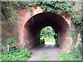
Bestwood: Great Northern Railway bridge near Forge Farm
The Great Northern Leen Valley Line, built to carry coal from the Leen Valley pits, opened in 1881 and closed in 1964, having lost its passenger service (duplicated by the Midland and Great Central routes) as early as 1931. This was Bridge No 7. The trees visible through the arch, on the other side of Moor Road, are growing on the site of the Midland Railway line to Bestwood Colliery, which crossed the road there before burrowing through the high Great Northern embankment to reach the colliery.
For more about the GNR at Bestwood, see Image], Image], Image] and Image]
Image: © John Sutton
Taken: 13 Jul 2011
0.06 miles
8
Millbank Place, Bestwood, Notts.
Millbank Place (ahead) is part of a horse-shoe shaped residential street that has been developed on ground previously owned by Bayles & Wylie. Forge Mill - a corner of which is seen here - was the last piece of property the company owned in Bestwood. It is Grade II-listed, straddles the River Leen and has a mill pond behind it. It was built as a cotton mill by the Robinson family (c.1783) on premises originally used as an iron foundry, hence its name. Consent was granted in November 2012 to convert the upper floors into 11 apartments "and for a charity to use the grounds and the first floor for textile-based employment purposes". Robin Hood Way - a long distance path - passes the front of the mill.
Image: © David Hallam-Jones
Taken: 24 Jan 2014
0.07 miles
9
Bestwood: The Old Mill
One of many water-powered mills in the Leen Valley, this mill at Bestwood was built about 1783 and rebuilt after a fire in 1838. Originally a cotton mill, it was later a corn mill and subsequently a store. It was last used in the 1970s. For more about it, see Howard Fisher's Thoroton Society article: http://www.thorotonsociety.org.uk/publications/articles/bestwoodmill.htm
Image: © John Sutton
Taken: 13 Jul 2011
0.07 miles
10
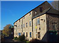
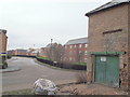
Nottingham, NG6 - Mill Lane
Early November 2012 saw the completion of a sales contract that is intended to underpin the development of this former mill in Mill Lane, Bestwood. This marks the end of its fourth generation of family ownership since Bayles & Wylie are now operating exclusively out of modern industrial premises in Calverton. Forge Mill was the last piece of property owned by the company in Bestwood, most of the surrounding mill land having already been sold off for new homes in the vicinity referred to as Millbank Place. This Grade II-listed building straddling the River Leen overlooks a mill pond at the rear. It was built as a cotton mill by the Robinson family - c.1783 - on the same premises as an existing iron foundry. For the time being(?) a public footpath at the rear of the mill is no longer accessible. Whilst the new owners have consent to convert the upper floors into 11 apartments, it has been reported that "a deal has been done with a charity who will use the grounds and the first floor for textile-based employment purposes".
Image: © David Hallam-Jones
Taken: 17 Nov 2012
0.07 miles