IMAGES TAKEN NEAR TO
Arch Hill, NOTTINGHAM, NG5 8PF
Introduction
This page details the photographs taken nearby to Arch Hill, NG5 8PF by members of the Geograph project.
The Geograph project started in 2005 with the aim of publishing, organising and preserving representative images for every square kilometre of Great Britain, Ireland and the Isle of Man.

There are currently over 7.5m images from over14,400 individuals and you can help contribute to the project by visiting https://www.geograph.org.uk
Image Map
Images are licensed for reuse under creativecommons.org/licenses/by-sa/2.0
Notes
- Clicking on the map will re-center to the selected point.
- The higher the marker number, the further away the image location is from the centre of the postcode.
Image Listing (32 Images Found)
Images are licensed for reuse under creativecommons.org/licenses/by-sa/2.0
Image
Details
Distance
1
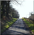
Red Hill, Redhill, NG5, Notts.
This minor road is a left-hand turning off the main Mansfield-Nottingham Road (the A60) 500m south of the unofficially-named "Banyan Tree roundabout". This is part of the former London-York (via Nottingham) Road as it rises up Red Hill Ridge, parallel with the A60 that is situated on the other side of the stone wall. In 1218 this stretch of the road was referred to as the "rubeam rodam" (the red road)" according to the Revs. R.W. King & J. Russell (eds), in "A History of Arnold" (1913). At the crown of the hill a road bridge to the right carries a limited amount of traffic over the A60 to another part of this hamlet; to the Leapool Allotments site (Gedling Borough Council) and to two covered reservoirs, the Redhill and the Wernbank reservoirs.
Image: © David Hallam-Jones
Taken: 16 Feb 2014
0.03 miles
2
Red Hill, Redhill, NG5, Notts.
The Leapool Allotment site (owned by the Borough of Gedling); a row of well-established and expensive homes; plus the Redhill covered reservoir (managed by the Severn Trent Company) are all situated on other side of this bridge. The A60 (the Nottingham-Mansfield Road) runs beneath it. This is the crown of the hill - through which a path for the A60 was cut - and this short 'branch' road descends both in front of the photographer and behind too. The access points and exits to/from this branch road are onto and from the A60.
Image: © David Hallam-Jones
Taken: 16 Feb 2014
0.04 miles
3
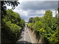
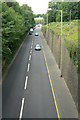
A60 Mansfield Road, Redhill
Looking towards Mansfield from the bridge that crosses the cutting through which Mansfield Road passes at this point.
Image: © Richard Vince
Taken: 12 Aug 2017
0.04 miles
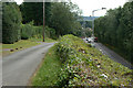
5
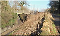
Red Hill Cutting
The cutting was created in 1815 to ease the gradient on the main road north out of Nottingham. It is cut through mudstones and the underlying Bunter Sandstone. This is the view looking north towards Leapool Island.
Image: © Alan Murray-Rust
Taken: 6 Jul 2010
0.05 miles
6
Bridge over A60, Red Hill, Redhill, NG5, Notts.
The road bridge over the A60 (the Nottingham-Mansfield) road. This provides access - behind the photographer - to two reservoirs, i.e. the Redhill and Wernbank reservoirs; to Gedling Borough Council's Leapool Allotment site and to about a third of the residential properties that form this hamlet. The cutting that allows for the passage of the A60 was carved out in 1787. A stone arch carrying residential and agricultural traffic over the cutting collapsed in 1890 and was subsequently replaced a replacement metal bridge paid for jointly by the local authority and local landowners. In 1928 the cutting was widened to allow for road widening and the bridge seen here was installed.
Image: © David Hallam-Jones
Taken: 16 Feb 2014
0.05 miles
7
Red Hill, Redhill, NG5, Notts.
The hamlet of Red Hill in Redhill sits on the crown of this hill. This short branch road - that runs parallel with the A60 (Nottingham-Mansfield Road) seen here on the left - serves a row of long-established and expensive houses ahead (on the right) and another row of equally long-established and expensive houses on the other side of the bridge. The Leapool allotment site (that is owned by the Borough of Gedling) is also situated on the left-hand side of this bridge, as is the Redhill covered reservoir (managed by the Severn Trent Company). In 1218 this stretch of the former Old North Road (London to York, via Nottingham) was referred to as the "rubeam rodam" (the red road)", according to the Revs. R.W. King & J. Russell (eds), in A History of Arnold (1913). The cutting that allows for the passage of the Nottingham to Mansfield Road was carved out in 1787. A stone arch carrying residential and agricultural traffic over this cutting collapsed in 1890 and was subsequently replaced a replacement metal bridge paid for jointly by the local authority and local landowners. In 1928 the cutting was widened to allow for road widening and this bridge was installed.
Image: © David Hallam-Jones
Taken: 16 Feb 2014
0.05 miles
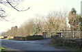
8
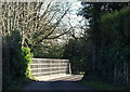
Leapool Allotments, Red Hill, Redhill, NG5, Notts.
The entrance to Gedling Borough Council's Leapool Allotment site in the hamlet of Red Hill.
Image: © David Hallam-Jones
Taken: 16 Feb 2014
0.06 miles
9
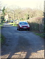
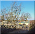
Leapool Allotments, Red Hill, Redhill, NG5, Notts.
The light on the road in the foreground of this picture is sunlight streaming through the security railings of the road traffic bridge that spans the A60 (Nottingham-Mansfield Road) from west to east in the hamlet of Red Hill. Behind the red car is the entrance to the Leapool Allotment site that is managed by Gedling Borough Council. In the distance is the entrance to the Redhill covered reservoir that is owned by the Severn Trent Company.
Image: © David Hallam-Jones
Taken: 16 Feb 2014
0.06 miles
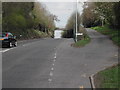
10
Arch Hill
The lane to the left is the remains of the old road which was left in situ when the cutting was created. This view gives some idea of the extent to which the summit was lowered. (See http://www.geograph.org.uk/photo/1952990 )
Image: © Alan Murray-Rust
Taken: 6 Jul 2010
0.06 miles