IMAGES TAKEN NEAR TO
Clumber Avenue, NOTTINGHAM, NG5 1RN
Introduction
This page details the photographs taken nearby to Clumber Avenue, NG5 1RN by members of the Geograph project.
The Geograph project started in 2005 with the aim of publishing, organising and preserving representative images for every square kilometre of Great Britain, Ireland and the Isle of Man.

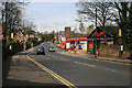
There are currently over 7.5m images from over14,400 individuals and you can help contribute to the project by visiting https://www.geograph.org.uk
Image Map
Images are licensed for reuse under creativecommons.org/licenses/by-sa/2.0
Notes
- Clicking on the map will re-center to the selected point.
- The higher the marker number, the further away the image location is from the centre of the postcode.
Image Listing (184 Images Found)
Images are licensed for reuse under creativecommons.org/licenses/by-sa/2.0
Image
Details
Distance
1
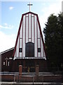
Polish Roman Catholic Church, Sherwood Rise
Image: © Oxymoron
Taken: 17 Aug 2008
0.02 miles
2
Polish Church on Sherwood Rise
Dedicated to Our lady of Chestachowa.
Image: © Alan Murray-Rust
Taken: 15 Mar 2009
0.02 miles
3
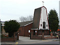
The Polish Eagle Centre, Clumber Avenue
The Polish Church of Our Lady of Czestochow is just round the corner on Sherwood Rise. The Latin motto reads "No other governs".
Image: © John Sutton
Taken: 5 Sep 2013
0.02 miles
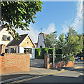
4
Clarendon Park - the site of Carrington railway station
This business park is built on the filled-in site of Carrington Station, which stood between Mansfield Road and Sherwood Rise Tunnels on the Great Central line from Nottingham Victoria. The platforms were about 25ft below the present ground level. The station was only open to passengers from 1899-1928 (trams were a more convenient way to and from the city), but its derelict remains were a good place for truanting schoolboys to go trainspotting until the line closed in 1968. The south portal of Sherwood Rise Tunnel was directly under where the cars are parked; the red-brick wall to their left, belonging to the Victorian house on Clumber Avenue, was the boundary of the railway land. For an idea of Carrington Station nearly 50 years before, see Image
Image: © John Sutton
Taken: 27 Apr 2011
0.02 miles
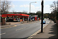
5
Sherwood Rise
Heading towards Basford.
Changed little in the last thirty years.
Image: © David Lally
Taken: 13 Apr 2010
0.03 miles
6
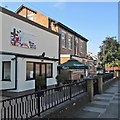
Petrol Station on Sherwood Rise
Looking pretty much how I remember it from 1978.
Image: © David Lally
Taken: 13 Apr 2010
0.05 miles
7
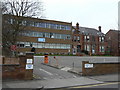
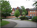
Clumber House
Part modern, part Victorian villa, now part of Clendon College, itself now part of New College Nottingham, principally a vocational technical college.
Image: © Alan Murray-Rust
Taken: 15 Mar 2009
0.05 miles
8
Sherwood Rise: two churches
The Polish church is on the left and the Victorian spire of St Andrew's, on Mansfield Road, is on the horizon.
Image: © John Sutton
Taken: 27 Apr 2011
0.05 miles
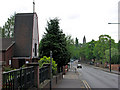
9
The corner of First Avenue and Sherwood Rise
First, Second and Third Avenues were some of the first suburban developments north of The Forest, with some substantial houses dating from c 1850-70, the period of the Borough's initial expansion after the Enclosure Act of 1845. The striking west front of the Polish Church of Our Lady of Czestochow is on the other side of Sherwood Rise.
Image: © John Sutton
Taken: 5 Sep 2013
0.05 miles
10
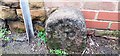
Lenton Parish boundary stone at junction of First Avenue and Sherwood Rise
The stone has the Milestone Society National ID: NT_NOT36pb and bears the inscription L P / 1855. Lenton was absorbed into Nottingham Parish in 1897 but there were earlier parish boundary changes in 1880.
Image: © Roger Templeman
Taken: 29 Jan 2022
0.06 miles