IMAGES TAKEN NEAR TO
Inger Drive, NG4 4NJ
Introduction
This page details the photographs taken nearby to Inger Drive, NG4 4NJ by members of the Geograph project.
The Geograph project started in 2005 with the aim of publishing, organising and preserving representative images for every square kilometre of Great Britain, Ireland and the Isle of Man.

There are currently over 7.5m images from over14,400 individuals and you can help contribute to the project by visiting https://www.geograph.org.uk
Image Map
Images are licensed for reuse under creativecommons.org/licenses/by-sa/2.0
Notes
- Clicking on the map will re-center to the selected point.
- The higher the marker number, the further away the image location is from the centre of the postcode.
Image Listing (75 Images Found)
Images are licensed for reuse under creativecommons.org/licenses/by-sa/2.0
Image
Details
Distance

2
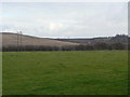
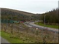
Field alongside Arnold Lane
The prominent hill to the left is the spoil heap of the former Gedling Colliery which lay behind the hedge to the right hand side of the picture.
Image: © Alan Murray-Rust
Taken: 1 Feb 2009
0.10 miles
3
View towards Chase Farm from the beacon
An update on https://www.geograph.org.uk/photo/7054775 from 18 months earlier.
Image: © Alan Murray-Rust
Taken: 14 May 2023
0.11 miles
4
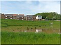
Attenuation pond, Chase Farm
The muddiness of the water is due to the fact that it is draining off the continuing construction area, with plenty of mud on the roads.
Image: © Alan Murray-Rust
Taken: 14 May 2023
0.12 miles
5
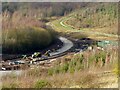
Gedling Access Road construction 240121 ? 4
The roadway is beginning to take shape with kerbing and some of the main base material in position.
Image: © Alan Murray-Rust
Taken: 24 Jan 2021
0.13 miles
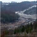
6
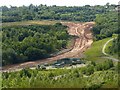
Gedling Access Road construction ? 251221 ? 6
The northern section of the road past Gedling Country Park nearing completion, looking south.
Image: © Alan Murray-Rust
Taken: 25 Dec 2021
0.14 miles
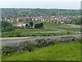
7
Arnold Lane, Gedling
Currently the A 6211, a major suburban through route, shortly to be superseded by the new Gedling Access Road.
Image: © Alan Murray-Rust
Taken: 30 May 2020
0.14 miles
8
Gedling Access Road progress - July 2020
On the edge of Gedling Country Park, with the methane powered generating station in the foreground. This captures gas from the underground workings of the former Gedling Colliery.
Image: © Alan Murray-Rust
Taken: 5 Jul 2020
0.15 miles
9
Gedling Access Road construction - December 2020
The carriageway of the section passing Gedling Country Park is beginning to take shape.
Image: © Alan Murray-Rust
Taken: 14 Dec 2020
0.15 miles
10
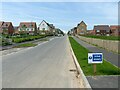
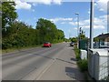
Harviston Avenue, Chase Farm
This forms the main spine road of the estate. As the estate is still under construction, a final tarmac surface layer has yet to be applied and the road is subject to a (nominal!) 10 mph limit.
Image: © Alan Murray-Rust
Taken: 14 May 2023
0.15 miles