IMAGES TAKEN NEAR TO
Kenrick Street, NOTTINGHAM, NG4 2AA
Introduction
This page details the photographs taken nearby to Kenrick Street, NG4 2AA by members of the Geograph project.
The Geograph project started in 2005 with the aim of publishing, organising and preserving representative images for every square kilometre of Great Britain, Ireland and the Isle of Man.

There are currently over 7.5m images from over14,400 individuals and you can help contribute to the project by visiting https://www.geograph.org.uk
Image Map
Images are licensed for reuse under creativecommons.org/licenses/by-sa/2.0
Notes
- Clicking on the map will re-center to the selected point.
- The higher the marker number, the further away the image location is from the centre of the postcode.
Image Listing (48 Images Found)
Images are licensed for reuse under creativecommons.org/licenses/by-sa/2.0
Image
Details
Distance
1
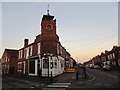
Tower on the corner of Kenrick Street and Chandos Street
Former Ceylon Tea House. The tower once housed a bell.
Image: © Jonathan Thacker
Taken: 7 Dec 2015
0.02 miles
3
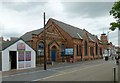
Netherfield Baptist Chapel
Dated 1892. The smaller building appears to have been the actual chapel, the larger being a hall.
Image: © Alan Murray-Rust
Taken: 4 Jul 2016
0.04 miles
4
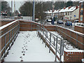
Snowy ramp
Access ramp to the eastbound platform at Carlton Station. This is unmanned so no clearance work has been done since the recent snowfall.
Image: © Alan Murray-Rust
Taken: 2 Feb 2009
0.05 miles
5
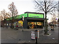
Co-op store, Netherfield
In the centre of the shopping area.
Image: © Jonathan Thacker
Taken: 7 Dec 2015
0.06 miles
6
Carlton Station looking east
Recreating this earlier view from 2007 https://www.geograph.org.uk/photo/312700 . Since then the crossing barriers have been renewed and set back a little further from the tracks. Otherwise the change is minimal.
Image: © Alan Murray-Rust
Taken: 23 May 2021
0.06 miles
7
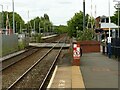
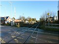
Carlton level crossing
The platforms of Carlton station, on the Nottingham-Lincoln line, are staggered, the eastbound platform to the left of the crossing, the westbound to the right. The station was formerly Carlton & Netherfield, to distinguish it from Netherfield & Colwick on the Grantham line. Carlton is behind the camera, Netherfield (a one-time railway town) straight ahead.
Image: © John Sutton
Taken: 22 Aug 2013
0.06 miles
8
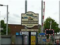
Netherfield 'village' sign
These cast signs were originally created for rural villages, but have spread to include urban 'villages' as well. This shows (top) the former Netherfield Junction Signal Box https://www.geograph.org.uk/photo/312689 , Jackie Bell's Field playground (left) and the St George's Centre (bottom). I have not identified the fourth element.
Image: © Alan Murray-Rust
Taken: 23 May 2021
0.06 miles
9
Carlton Station
Due to space considerations, the station has always been laid out with staggered platforms.
Image: © Alan Murray-Rust
Taken: 17 Dec 2020
0.06 miles
10
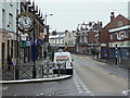
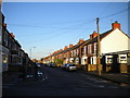
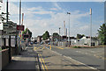
Victoria Street, Netherfield
Local shopping centre still with a variety of shops which have not succumbed entirely to the takeaway/estate agent syndrome.
Image: © Alan Murray-Rust
Taken: 2 Feb 2009
0.06 miles