IMAGES TAKEN NEAR TO
Woodthorpe Road, NOTTINGHAM, NG3 5QH
Introduction
This page details the photographs taken nearby to Woodthorpe Road, NG3 5QH by members of the Geograph project.
The Geograph project started in 2005 with the aim of publishing, organising and preserving representative images for every square kilometre of Great Britain, Ireland and the Isle of Man.

There are currently over 7.5m images from over14,400 individuals and you can help contribute to the project by visiting https://www.geograph.org.uk
Image Map
Images are licensed for reuse under creativecommons.org/licenses/by-sa/2.0
Notes
- Clicking on the map will re-center to the selected point.
- The higher the marker number, the further away the image location is from the centre of the postcode.
Image Listing (47 Images Found)
Images are licensed for reuse under creativecommons.org/licenses/by-sa/2.0
Image
Details
Distance
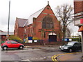
1
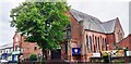
Mapperley Church on NW side of Woodborough Road
Image: © Roger Templeman
Taken: 10 May 2022
0.04 miles
2
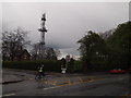
Nottingham - NG3
A cyclist peddling along Woodborough Road (B684) in the direction of Mapperley at the junction of Woodthorpe Road on a wet April afternoon. The Mapperley Ridge radio transmitter towers above everything else. Adjacent to the transmitter is a brick-built house belonging to the Severn-Trent Water Authority and behind the (now unused) gates the raised profile of a covered reservoir can be seen.
Image: © David Hallam-Jones
Taken: 20 Apr 2012
0.04 miles
3
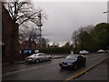
Nottingham - NG3
A view of part of Woodborough Road (B684) and its junction with Woodthorpe Road taken on a wet April afternoon. Features appearing include the corner of Mapperley Methodist Church and the Mapperley Ridge radio transmitter. Adjacent to the transmitter is a brick-built house belonging to the Severn-Trent Water Authority. Behind the "Caution Bumps Ahead" sign it is just possible to make out the raised profile of a covered reservoir.
Image: © David Hallam-Jones
Taken: 20 Apr 2012
0.04 miles
4
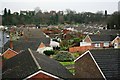
Former Mapperley Brickworks
Now covered by residential housing, in the sixties there were several ponds in this area resulting from the brick works where I used to collect newts.
Image: © Mick Garratt
Taken: 5 Jan 2007
0.05 miles
5
Nottingham - NG3
A view across Woodborough Road (B684) from Eaton Street featuring Mapperley Methodist Church. The church occupies a prominent position in this neighbourhood, known is locally as "Mapperley Top". Behind the tree another landmark – the Mapperley Ridge radio transmitter – can be seen.
Image: © David Hallam-Jones
Taken: 20 Apr 2012
0.05 miles
6
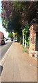
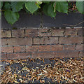
Brick wall bounding covered reservoir on north side of Woodborough Road
There is an Ordnance Survey benchmark Image on the road face of the brick pier
Image: © Roger Templeman
Taken: 8 May 2022
0.06 miles
7
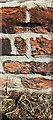
Benchmark on brick wall pier on north side of Woodborough Road
Ordnance Survey cut mark benchmark levelled at 128.205m above Newlyn Datum in 1962
Image: © Roger Templeman
Taken: 8 May 2022
0.06 miles
8
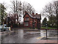
Nottingham - NG3
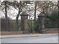
Drivers and pedestrians successfully getting to the top of Porchester Road - the long uphill route from Carlton Road, NG4 (the B686) - are treated to this sight at the junction with Woodborough Rd, although sometimes it is more sunlit. The land and the covered reservoir inside the gate (and perhaps the house too) belong to the Severn Trent Water Authority, although the house appears to have been divided into several flats. To the left of the house the "Mapperley Ridge" radio transmitter can be seen, albeit that it stands on a separate plot of land. The "Water Board" site, the transmitter and the area beyond it, plus the area the left-hand side of this picture are in the NG5 postal area, Porchester Road acting as the boundary.
Image: © David Hallam-Jones
Taken: 21 Apr 2012
0.06 miles
9
Mapperley
Visited all possible gates to this well guarded reservoir compound. Formerly joint UA Top for Nottingham but hill 5527 Nottingham M1 is now believed to be higher.
Name: Mapperley
Hill number: 5528
Height: 130m / 427ft
Area: 37: The River Tees to The Wash
Class: Un
Grid ref: SK 58790 43105
Summit feature: by reservoir gate
Drop: 18m
Col: 112m SK602449
Image: © Rude Health
Taken: 30 Jan 2011
0.07 miles
10
Bench Mark, Woodborough Road
On the wall surrounding Mapperley Reservoir.
Image: © Alan Murray-Rust
Taken: 30 Jul 2014
0.10 miles