IMAGES TAKEN NEAR TO
Northgate, SLEAFORD, NG34 7BS
Introduction
This page details the photographs taken nearby to Northgate, NG34 7BS by members of the Geograph project.
The Geograph project started in 2005 with the aim of publishing, organising and preserving representative images for every square kilometre of Great Britain, Ireland and the Isle of Man.

There are currently over 7.5m images from over14,400 individuals and you can help contribute to the project by visiting https://www.geograph.org.uk
Image Map
Images are licensed for reuse under creativecommons.org/licenses/by-sa/2.0
Notes
- Clicking on the map will re-center to the selected point.
- The higher the marker number, the further away the image location is from the centre of the postcode.
Image Listing (346 Images Found)
Images are licensed for reuse under creativecommons.org/licenses/by-sa/2.0
Image
Details
Distance
1
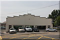
Sleaford MOT and Service Centre, 61 North Gate, Sleaford
Image: © Jo and Steve Turner
Taken: 12 Jul 2013
0.00 miles
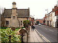
2
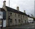
51 and 53 Northgate, Sleaford
Mid nineteenth century cottages. https://www.britishlistedbuildings.co.uk/101360428-51-and-53-northgate-sleaford#.Wez3JIhrzVI
Image: © Jonathan Thacker
Taken: 20 Oct 2017
0.00 miles
3
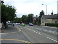
North Gate (B1518), Sleaford
Heading north.
Image: © JThomas
Taken: 20 Jul 2013
0.01 miles
4
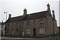
51 and 53 North Gate, Sleaford
Two Grade II Listed mid 19th century Gothic style cottages.
Image: © Jo and Steve Turner
Taken: 12 Jul 2013
0.01 miles
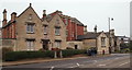
5
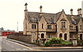
North Gate/Church Lane, Sleaford, Lincs.
Sleaford's "Community Fire Station" on Church Lane can be seen here near the north-east corner of the site occupied by the Northgate Almshouses. This almshouse building was constructed in 1857 as an addition to the Carre’s Hospital Almshouses in Eastgate. Church Lane passes the front of the fire station and forms a 'c' shaped arc around the back of the almshouses before it rejoins North Gate half a mile further on towards the town centre. The principal road at this junction is the B1518.
Image: © David Hallam-Jones
Taken: 29 Nov 2014
0.01 miles
6
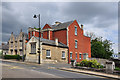
Corner of Church Lane - Sleaford
Carre's Grammar School is located here between Church Lane and Mill Field Terrace.
Image: © Mick Lobb
Taken: 17 May 2010
0.02 miles
7
North Gate, Sleaford, Lincs.
Two buildings on the east side of Northgate in the Galley Hill area, with the B1518 beginning to descend towards the town centre on the right of the picture. The side road is Church Lane, which very quickly curves to form an arc round the back of these buildings and rejoins North Gate half a mile further on towards the town centre. The larger building constitutes the Northgate Almshouses built in 1857 as an addition to the Carre’s Hospital Almshouses in Eastgate. The smaller building - part of the same development - bears a stone inscription declaring it to be a "Savings Bank".
Image: © David Hallam-Jones
Taken: 29 Nov 2014
0.02 miles
8
North Gate, Sleaford, Lincs.
The building on left sits in the south-west corner of a site on the east side of North Gate that is occupied - for the most part - by the Northgate Almshouses. These were built in 1857 as an addition to the Carre’s Hospital Almshouses in Eastgate. However, the converted building ahead, with the Carre family crest on its chimney stack, bears a stone inscription on its road-facing elevation declaring it to be a "Savings Bank". It is now a residential property. The road here is the B1518, as it begins its descent towards the town centre.
Image: © David Hallam-Jones
Taken: 29 Nov 2014
0.02 miles
9
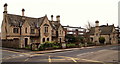
North Gate (Galley Hill), Sleaford, Lincs.
A view along the east side of North Gate. This is a section of North Gate - i.e. the B1518 - furthest from the town centre. The street lamp marks its junction with Church Lane, in which the town's Fire Station is situated. Beyond the lamp and facing this 'main' road are the Northgate Almshouses. The buildings on the left form part of the Grade II-listed Carre's Grammar School. As a result of the gradual development of the school site over several hundred years a number of buildings in differing architectural styles can be seen fronting different sections of North Gate. The school was founded in 1604 as the result of a bequest by Robert Carre, of Aswarby, to provide for the education of local boys. It seems that the school went into a period of decline, effectively closing in 1816. However, a group of trustees purchased land in 1826 and secured funding in 1830 for the construction of new buildings and it reopened in 1835. Further extensions were added in the 1900s and these were added to in the 1940s and 1950s. The school became grant-maintained in 1991. It received Specialist Sports College status in 2003, Science specialist status in 2009 and it became an Academy in 2011.
Image: © David Hallam-Jones
Taken: 29 Nov 2014
0.02 miles