IMAGES TAKEN NEAR TO
Main Street, GRANTHAM, NG33 5RF
Introduction
This page details the photographs taken nearby to Main Street, NG33 5RF by members of the Geograph project.
The Geograph project started in 2005 with the aim of publishing, organising and preserving representative images for every square kilometre of Great Britain, Ireland and the Isle of Man.

There are currently over 7.5m images from over14,400 individuals and you can help contribute to the project by visiting https://www.geograph.org.uk
Image Map
Images are licensed for reuse under creativecommons.org/licenses/by-sa/2.0
Notes
- Clicking on the map will re-center to the selected point.
- The higher the marker number, the further away the image location is from the centre of the postcode.
Image Listing (71 Images Found)
Images are licensed for reuse under creativecommons.org/licenses/by-sa/2.0
Image
Details
Distance
1
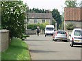
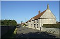
Main Street in Sewstern, Leicestershire
Sewstern is Leicestershire's easternmost village.
Image: © Mat Fascione
Taken: 10 May 2008
0.02 miles
2
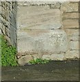
Bench mark, 12 Main Street, Sewstern
See http://www.geograph.org.uk/photo/5194861 for location.
Image: © Alan Murray-Rust
Taken: 13 Nov 2016
0.03 miles
3
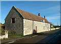
12 Main Street, Sewstern
Barn with cottage attached.
There is a bench mark http://www.geograph.org.uk/photo/5194853 on the near corner.
Image: © Alan Murray-Rust
Taken: 13 Nov 2016
0.03 miles
4
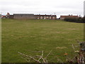
Quarried pasture land, Sewstern
Buckminster Ironstone quarry no 8, active (approx) between 1937 and 1948. The quarry workings were allowed quite close to the village. Although this is a modern farm building it might have replaced another that determined the edge of the quarry working. Reference - E Tonks, The Ironstone Quarries of the Midlands, Part 8, South Lincolnshire.
Image: © Michael Trolove
Taken: 26 Feb 2017
0.04 miles
5
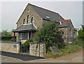
The Old Chapel, Sewstern
Located along Main Street.
Image: © Mat Fascione
Taken: 10 May 2008
0.04 miles
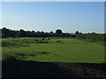
7
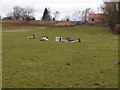
Quarried Landscape
Although looking like a standard pony paddock between 1937 and 1948 this area was quarry no8 in the Buckminster Ironstone Quarries scheme and a connecting railway would have lain in this field. See Image The cap stone on the distant wall denote the railway bridge that allows passage under Sewswtern Main Street.
Image: © Michael Trolove
Taken: 26 Feb 2017
0.06 miles
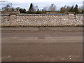
8

Cap stones on a wall
Unless you know the past geographical history of this area you would think that these are just standard wall cappings but if you scraped away the soil on the other side of the wall you would find that this is a railway bridge for the ironstone quarries that were worked in this parish.
A book by Eric Tonks on the Ironstone Quarries of the Midlands Pt 8 South Midlands has two photographs Pg 24 of the cut being dug 1947 and another of the Locomotive travelling through floods in 1953.
Looking over the wall you will see the undulations of the land and it is noteworthy to see how close to the village properties the quarrying was allowed to get. Remediation work allowed the land to be returned to agriculture.
Image: © Michael Trolove
Taken: 26 Feb 2017
0.06 miles
9
Opposite wall cap stones
Unless you know the past geographical history of this area you would think that these are just standard wall cappings but if you scraped away the soil on the other side of the wall you would find that this is a railway bridge for the ironstone quarries that were worked in this parish.
A book by Eric Tonks on the Ironstone Quarries of the Midlands Pt 8 South Midlands has two photographs Pg 24 of the cut being dug 1947 and another of the Locomotive travelling through floods in 1953.
Looking over the wall you will see the undulations of the land and it is noteworthy to see how close to the village properties the quarrying was allowed to get. Remediation work allowed the land to be returned to agriculture.
Image: © Michael Trolove
Taken: 26 Feb 2017
0.07 miles