IMAGES TAKEN NEAR TO
West End Close, GRANTHAM, NG33 5NB
Introduction
This page details the photographs taken nearby to West End Close, NG33 5NB by members of the Geograph project.
The Geograph project started in 2005 with the aim of publishing, organising and preserving representative images for every square kilometre of Great Britain, Ireland and the Isle of Man.

There are currently over 7.5m images from over14,400 individuals and you can help contribute to the project by visiting https://www.geograph.org.uk
Image Map
Images are licensed for reuse under creativecommons.org/licenses/by-sa/2.0
Notes
- Clicking on the map will re-center to the selected point.
- The higher the marker number, the further away the image location is from the centre of the postcode.
Image Listing (76 Images Found)
Images are licensed for reuse under creativecommons.org/licenses/by-sa/2.0
Image
Details
Distance
1
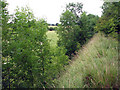
Woolsthorpe: trackbed of the High Dyke Branch and Colsterworth North Quarry
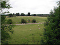
The High Dyke branch was built during the First World War to carry iron ore from quarries at Colsterworth, Skillington, Buckminster, Gunby and Sproxton to the East Coast Main line (the junction and sidings were in square SK9329) and closed in 1973. This view shows the edge of the railway embankment and the steep drop to what was Colsterworth North Quarry, worked from 1943-66, which filled the northern third of this square and much of SK9124. See other photos nearby for more on the quarries and railways in the area.
Image: © John Sutton
Taken: 27 Aug 2009
0.02 miles
2
Woolsthorpe: trackbed of the High Dyke Branch
The High Dyke branch was built during the First World War to carry iron ore from quarries at Colsterworth, Skillington, Buckminster, Gunby and Sproxton to the East Coast Main line (the junction and sidings were in square SK9329) and closed in 1973. This view is looking towards Colsterworth North Sidings and High Dyke. See other photos nearby for more on the railways and quarries in the area.
Image: © John Sutton
Taken: 27 Aug 2009
0.04 miles
3
Woolsthorpe: new and old Buckminster roads
The course of the road was moved to the south of the High Dyke Branch railway in 1966 as ironstone quarrying in the huge Colsterworth North Quarry, which took up all of the northern half of this gridsquare (and SK9124), moved south. The truncated old road is to the right, the current road to the left. The High Dyke Branch crossed the old road on the crest of the hill, just beyond the bungalow; the line of trees marks its course, which is now known as the Woolsthorpe Line Nature Reserve. See other photos nearby for more on the ironstone quarries and railways in the area.
Image: © John Sutton
Taken: 27 Aug 2009
0.05 miles
4
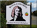
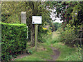
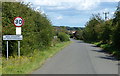
Sign at Woolsthorpe-by-Colsterworth
The sign is located along the lane on the western edge of the hamlet.
Woolsthorpe-by-Colsterworth is a hamlet in the South Kesteven district of Lincolnshire. It is best known as the birthplace of Sir Isaac Newton, at Woolsthorpe Manor. It lies 1km northwest of the larger village of Colsterworth, next to the A1 Great North Road.
Image: © Mat Fascione
Taken: 18 Aug 2019
0.06 miles
5
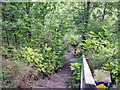
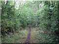
Woolsthorpe: steps on the Skillington footpath
The footpath crosses the trackbed of the High Dyke Branch. The steps lead down what was once an ironstone quarry face (Colsterworth North Quarry). See other photos nearby for more on the quarries and railways of the area.
Image: © John Sutton
Taken: 27 Aug 2009
0.08 miles
6
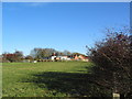
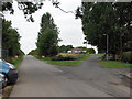
Houses at edge of Woolsthorpe-by-Colsterworth
The old Woolsthorpe railway line runs along the back of the houses.
Image: © Tim Heaton
Taken: 19 Nov 2006
0.09 miles
7
Woolsthorpe: trackbed of the High Dyke Branch
The High Dyke branch was built during the First World War to carry iron ore from quarries at Colsterworth, Skillington, Buckminster, Gunby and Sproxton to the East Coast Main line (the junction and sidings were in square SK9329) and closed in 1973. This is taken from where the railway once crossed the old road to Buckminster (the present road dates from 1966), looking towards Colsterworth North Sidings. It is easy to follow the trackbed between the trees. See other photos nearby for more on the quarries and railways in the area.
Image: © John Sutton
Taken: 27 Aug 2009
0.10 miles
8
Woolsthorpe: trackbed of the High Dyke Branch
The High Dyke branch was built during the First World War to carry iron ore from quarries at Colsterworth, Skillington, Buckminster, Gunby and Sproxton to the East Coast Main line (the junction and sidings were in square SK9329) and closed in 1973. This view of what is now the Woolsthorpe Line Nature Reserve is taken from where the railway once crossed the old road to Buckminster (the present road dates from 1966). The substantial concrete post next to the hedge once supported the level crossing gate.
Image: © John Sutton
Taken: 27 Aug 2009
0.10 miles
9
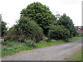
Colsterworth North Quarry: the lorry road
This photograph is taken from the trackbed of the High Dyke Branch. The tracks of the quarry railway once ran immediately below here, Colsterworth North Engine shed was just to the right and Colsterworth North Sidings a quarter of a mile further to the right. In the middle of the picture is the concrete "lorry road", built by United Steels in the mid 1960s, which was seen as a cheaper way of bringing ore to the railhead from outlying quarries than laying further railway lines. Known as "the M1", the lorry road ran NW and was intended to open up huge ore reserves in the Stoke Rochford and Ponton Heath areas. In the event it was never used as demand for ore dropped. Railways continued to be used at Colsterworth Quarries until closure. Kate Jewell's photos for Image and Image show the lorry road out in the country.
Image: © John Sutton
Taken: 27 Aug 2009
0.14 miles
10
Lane on the west edge of Woolsthorpe-by-Colsterworth
Woolsthorpe-by-Colsterworth is a hamlet in the South Kesteven district of Lincolnshire. It is best known as the birthplace of Sir Isaac Newton, at Woolsthorpe Manor. It lies 1km northwest of the larger village of Colsterworth, next to the A1 Great North Road.
Image: © Mat Fascione
Taken: 18 Aug 2019
0.15 miles