IMAGES TAKEN NEAR TO
Croxton Kerrial, GRANTHAM, NG32 1QJ
Introduction
This page details the photographs taken nearby to NG32 1QJ by members of the Geograph project.
The Geograph project started in 2005 with the aim of publishing, organising and preserving representative images for every square kilometre of Great Britain, Ireland and the Isle of Man.

There are currently over 7.5m images from over14,400 individuals and you can help contribute to the project by visiting https://www.geograph.org.uk
Image Map
Images are licensed for reuse under creativecommons.org/licenses/by-sa/2.0
Notes
- Clicking on the map will re-center to the selected point.
- The higher the marker number, the further away the image location is from the centre of the postcode.
Image Listing (16 Images Found)
Images are licensed for reuse under creativecommons.org/licenses/by-sa/2.0
Image
Details
Distance
1
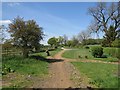
Sewstern Lane / The Drift near Hill Top Farm
Image: © Oliver Bell
Taken: 3 May 2014
0.03 miles
2
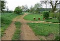
The Drift near Hill Top Farm
This track is known as The Drift and also The Viking Way Long Distance Footpath. It runs along the county boundary of Leicestershire and Lincolnshire.
Image: © Mat Fascione
Taken: 10 May 2008
0.04 miles
3
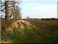
Sewstern Drift, just west of Hill Top Farm
The field boundary on the left corresponds to the boundary between the counties of Lincolnshire (to the left) and Leicestershire. The track is part of Sewstern Lane, an ancient drove road.
Image: © Stefan Czapski
Taken: 14 Mar 2009
0.04 miles
4
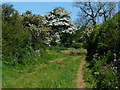
The Drift near Hill Top Farm
This track is known as The Drift or Sewstern Lane, the Viking Way Long Distance Footpath runs along the route of the track. It forms the county boundary of Leicestershire and Lincolnshire.
Image: © Mat Fascione
Taken: 17 May 2014
0.04 miles
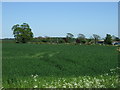
5
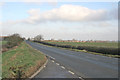
A 607, near Croxton Kerrial
The main Melton to Grantham road is a major feature in this square. Hill Top Farm is in the distance but still in the square.
Image: © Kate Jewell
Taken: 12 Jan 2006
0.09 miles
6
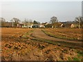
Hill Top Farm
Just inside Lincolnshire, on the boundary with Leicestershire. The OS map shows it sitting on the 140m contour. But this is a plateau, with none of the ups and downs of the Belvoir country a little to the north.
Image: © Stefan Czapski
Taken: 14 Mar 2009
0.11 miles
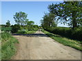
10
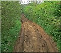
Very deeply rutted track
Known as The Drift and also The Viking Way, this track is almost completely impassable at this point. It runs along the county boundary of Leicestershire and Lincolnshire.
Image: © Mat Fascione
Taken: 10 May 2008
0.16 miles