IMAGES TAKEN NEAR TO
Knipton, GRANTHAM, NG32 1HA
Introduction
This page details the photographs taken nearby to NG32 1HA by members of the Geograph project.
The Geograph project started in 2005 with the aim of publishing, organising and preserving representative images for every square kilometre of Great Britain, Ireland and the Isle of Man.

There are currently over 7.5m images from over14,400 individuals and you can help contribute to the project by visiting https://www.geograph.org.uk
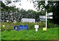
Image Map
Images are licensed for reuse under creativecommons.org/licenses/by-sa/2.0
Notes
- Clicking on the map will re-center to the selected point.
- The higher the marker number, the further away the image location is from the centre of the postcode.
Image Listing (26 Images Found)
Images are licensed for reuse under creativecommons.org/licenses/by-sa/2.0
Image
Details
Distance
4
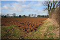
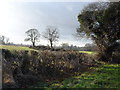
Farmland by Belvoir Road
The Belvoir Estate wood yard and saw mill are in the trees to the far right, just in Image Note the orange colour of the iron rich soil.
Image: © Kate Jewell
Taken: 30 Jan 2008
0.12 miles
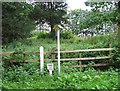
6

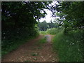
Minor road heading north, Windsor Hill
Towards Belvoir.
Image: © JThomas
Taken: 21 Jun 2014
0.14 miles
7
Faint traces of the ironstone railway at High Leys
The Waltham Iron Ore Co Ltd built a metre-gauge railway from the end of the standard gauge Eaton Branch (SK791309) to a number of quarries on the Terrace Hills, near Knipton Reservoir and at High Leys. The High Leys quarry was behind the trees and Granby and Harts quarries away to the right. The trackbed of the narrow-gauge railway can be seen as a curving line in the field, just below the Knipton road hedge. Ploughing has almost removed the embankment where the line followed the bend in the road, but it can still be made out in the centre left of this picture. The narrow-gauge railway operated from 1886-1958, and from 1936 on was probably unique in England in having two French locomotives, named "Nantes" and "Cambrai", the second of which is preserved at the Irchester Narrow Gauge Railway in Northamptonshire https://web.archive.org/web/20090907032209/http://www.ingrt.freeuk.com/04.htm .
Image: © John Sutton
Taken: 29 Apr 2009
0.16 miles
8
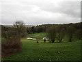
Ponds below Windsor Hill
Part of the Belvoir Estate.
Image: © Jonathan Thacker
Taken: 3 Feb 2020
0.16 miles
9
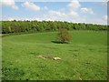
Views across towards High Leys Farm
Wonderful rural Leicestershire on a wonderful winter's day.
Image: © Ruth Raven
Taken: 28 Dec 2004
0.18 miles
10
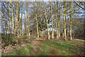
On Windsor Hill
To the west of the road at the top of Windsor Hill is Sir John's Belt, a band of beech trees; some old, probably part of an ancient avenue on the approach to Belvoir; many much younger. "John" is a frequent name in the Manners family, Dukes of Rutland of Belvoir Castle, but which John planted these old trees I do not know!
Image: © Kate Jewell
Taken: 30 Jan 2008
0.18 miles