IMAGES TAKEN NEAR TO
Stanley Road, NOTTINGHAM, NG2 6DF
Introduction
This page details the photographs taken nearby to Stanley Road, NG2 6DF by members of the Geograph project.
The Geograph project started in 2005 with the aim of publishing, organising and preserving representative images for every square kilometre of Great Britain, Ireland and the Isle of Man.

There are currently over 7.5m images from over14,400 individuals and you can help contribute to the project by visiting https://www.geograph.org.uk
Image Map
Images are licensed for reuse under creativecommons.org/licenses/by-sa/2.0
Notes
- Clicking on the map will re-center to the selected point.
- The higher the marker number, the further away the image location is from the centre of the postcode.
Image Listing (69 Images Found)
Images are licensed for reuse under creativecommons.org/licenses/by-sa/2.0
Image
Details
Distance
1
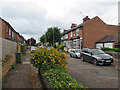
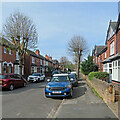
West Bridgford: Stanley Road
A cul-de-sac of fairly typical Bridgford villas, off Carnarvon Road, photographed on a cloudy July morning.
Image: © John Sutton
Taken: 6 Jul 2021
0.03 miles
2
West Bridgford Junior School, Exchange Road
The school was formerly known as South County Junior.
Image: © John Sutton
Taken: 3 Jul 2019
0.03 miles
3
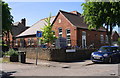
West Bridgford Junior School, at Exchange Road / Carnarvon Road junction
There is an OS benchmark Image on the Exchange Road (left hand) side of the wall corner, level with the no through road sign
Image: © Roger Templeman
Taken: 14 May 2018
0.04 miles
4
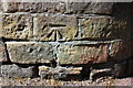
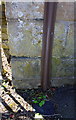
Benchmark on Exchange Road wall outside West Bridgford Junior School
Ordnance Survey cut mark benchmark levelled at 25.887m above Newlyn Datum with additional information to be found on the Bench Mark Database at www.bench-marks.org.uk/bm112892
Image: © Roger Templeman
Taken: 14 May 2018
0.05 miles
5
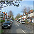
West Bridgford: Carnarvon Road
Looking towards Melton Road on the morning of Easter Sunday. This was one of many roads laid out as Bridgford expanded from village to populous suburb in the last years of the 19th century and the first decade of the twentieth - and in those days the anglicised spelling of Caernarfon was the accepted one.
Image: © John Sutton
Taken: 17 Apr 2022
0.06 miles
6
West Bridgford: across Manvers Road
Bright September sunlight and deep shadows in a twitchel which runs from Portland Road to Carnarvon Road (in the distance ahead), crossing Manvers Road.
Image: © John Sutton
Taken: 23 Sep 2021
0.08 miles
7
West Bridgford: Manvers Road
Looking from near the Exchange Road end towards Melton Road on the morning of Easter Sunday. This was one of many roads laid out as Bridgford expanded from village to populous suburb in the last years of the 19th century and the first decade of the twentieth.
Image: © John Sutton
Taken: 17 Apr 2022
0.08 miles
8
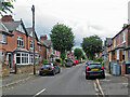
West Bridgford: along Carnarvon Road
These villas are a little grander than those in the next street, where my grandparents lived. Anglicised spelling of Welsh place names was usual when these houses were built.
Image: © John Sutton
Taken: 6 Jul 2021
0.08 miles
9
Benchmark on the wall in front of #4 Burleigh Road
Ordnance Survey cut mark benchmark, partly hidden behind cable guard, levelled at 28.164m above Newlyn Datum with more information on the Bench Mark Database at www.bench-marks.org.uk/bm112891
Image: © Roger Templeman
Taken: 14 May 2018
0.08 miles
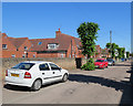
10
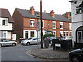
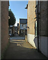
The corner of Manvers Road and Exchange Road
Image: © John Sutton
Taken: 30 Jun 2009
0.08 miles