IMAGES TAKEN NEAR TO
Westhorpe, SOUTHWELL, NG25 0ND
Introduction
This page details the photographs taken nearby to Westhorpe, NG25 0ND by members of the Geograph project.
The Geograph project started in 2005 with the aim of publishing, organising and preserving representative images for every square kilometre of Great Britain, Ireland and the Isle of Man.

There are currently over 7.5m images from over14,400 individuals and you can help contribute to the project by visiting https://www.geograph.org.uk
Image Map
Images are licensed for reuse under creativecommons.org/licenses/by-sa/2.0
Notes
- Clicking on the map will re-center to the selected point.
- The higher the marker number, the further away the image location is from the centre of the postcode.
Image Listing (75 Images Found)
Images are licensed for reuse under creativecommons.org/licenses/by-sa/2.0
Image
Details
Distance
1
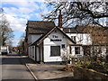
"The Dumbles", Southwell
Pub on B6386, Oxton Road, out of Southwell. Dumble is a local word for the deep cut valleys, with attendant streams, which are a feature of the high ground to the north east of Nottingham (see Image).
Image: © Oliver Dixon
Taken: 7 Mar 2014
0.00 miles
2
The Dumbles, Westhorpe
A pub that didn't do food, and at the time of our visit didn't do beer either.
Image: © Chris Morgan
Taken: 19 Jan 2015
0.01 miles
3
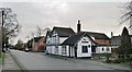
Westhorpe, Southwall NG25, Notts.
The local boundary between Southwell and the suburb of Westhorpe is just behind the photographer. Around the bend ahead is a crossroads formed by the convergence of four roads, although three of them are 'local' streets rather than main roads. The area at the centre of the crossroads was the former Market Place. "The Dumbles" public house was "The Lord Nelson" in a former life. Vehicles on this, "the Oxton Road" (the B6386), can opt to join the A6097 (the Epperstone By-Pass) a few miles further on.
Image: © David Hallam-Jones
Taken: 19 May 2013
0.01 miles
4
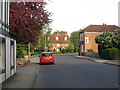
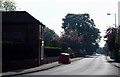
Early morning along Westgate, looking towards Sunnyside Cottages
Image: © Oliver Bell
Taken: 5 May 2014
0.02 miles
5
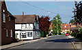
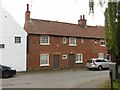
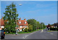
Westhorpe, Southwell NG25, Notts.
The boundary between this suburb and the Westgate area, both part of Southwell, is formed by an imaginary line across the road ahead, near the pillar box. The red car is parked outside of what is currently an “Antiques” shop, although it was known as “The Grapes Inn” between 1830-1975. Southwell lies a 3-4 minute drive ahead on this, the B6386.
Image: © David Hallam-Jones
Taken: 19 May 2013
0.04 miles
6
Ghost sign on building in Westhorpe
The building is now an antique shop and was formerly the Grapes Inn. There are at least two generations of lettering on this faded painted sign. One may read 'DAVY'S NEWARK ALES' (1830-1975).
Image: © Graham Hogg
Taken: 19 Jan 2015
0.05 miles
7
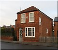
Antique shop in Westhorpe
A blue plaque states that this was the site of the Grapes Inn 1830-1975
Image: © Graham Hogg
Taken: 19 Jan 2015
0.05 miles
8
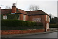
27 Westhorpe, Southwell
A pair of late 18th century cottages merged into a single dwelling, Listed Grade II together with no.29 to the right..
Image: © Alan Murray-Rust
Taken: 26 Jul 2020
0.06 miles
9
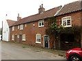
29 & 27 Westhorpe, Southwell
A row of originally 3, now 2, cottages, late 18th century, Listed Grade II.
Image: © Alan Murray-Rust
Taken: 26 Jul 2020
0.06 miles
10
Westhorpe, Southwell NG25, Notts.
Four roads converge here at the point formerly known as the Market Place. Vehicles on this, "the Oxton Road" (the B6386), can continue ahead and join the A6097 (the Epperstone By-Pass) a few miles ahead. The centre of Southwell lies a 4-5 minute drive away behind the photographer. The row of cottages behind the tall tree are all that remain of sixteen back-to-back properties that are said to have been used as dwellings and places of work by "stockingers" (stocking frame operators) during the late C16th.
Image: © David Hallam-Jones
Taken: 19 May 2013
0.06 miles