IMAGES TAKEN NEAR TO
Bond Street, NOTTINGHAM, NG2 4QX
Introduction
This page details the photographs taken nearby to Bond Street, NG2 4QX by members of the Geograph project.
The Geograph project started in 2005 with the aim of publishing, organising and preserving representative images for every square kilometre of Great Britain, Ireland and the Isle of Man.

There are currently over 7.5m images from over14,400 individuals and you can help contribute to the project by visiting https://www.geograph.org.uk
Image Map
Images are licensed for reuse under creativecommons.org/licenses/by-sa/2.0
Notes
- Clicking on the map will re-center to the selected point.
- The higher the marker number, the further away the image location is from the centre of the postcode.
Image Listing (282 Images Found)
Images are licensed for reuse under creativecommons.org/licenses/by-sa/2.0
Image
Details
Distance
1
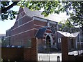
St. Alban's Church, Bond Street, Sneinton
By George Frederick Bodley.
Image: © Andrew Abbott
Taken: 21 Jun 2008
0.01 miles
2
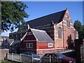
St. Alban's Church, Bond Street, Sneinton
By George Frederick Bodley
Image: © Andrew Abbott
Taken: 21 Jun 2008
0.01 miles
3
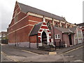
Nottingham - NG3 (Sneinton)
West Street becomes Bond Street at this corner, on which is also situated a Ukrainian Catholic Church. The small church hall immediately in front of it seems likely to have been added later?
Image: © David Hallam-Jones
Taken: 7 May 2012
0.02 miles
5
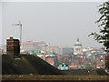
Sneinton view - 1
A foreshortened zoom view from Windmill Lane, over the rooftops of Walker Street, towards the Council House and the unpleasant high-rise blocks of Maid Marian Way.
Image: © John Sutton
Taken: 15 Apr 2011
0.04 miles
6
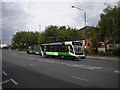
Bus near the bottom of Carlton Road
A 100 from Southwell nears the end of its journey as it reaches the bottom of Carlton Road, Nottingham, just a short distance from the city centre.
Image: © Richard Vince
Taken: 23 Jul 2011
0.05 miles
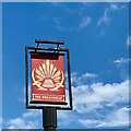
8
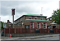
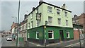
The Wheatsheaf, Sneinton Road, Nottingham
Estate pub built in 1964 by C. Howitt & Partners.
Image: © Stephen Richards
Taken: 19 Jun 2015
0.06 miles
9
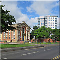
Sneinton Road: contrasts
On the left is the former Albion Congregational Church (1856). Further away are the high-rise Bentinck Court flats, built by Nottingham City Council.
Image: © John Sutton
Taken: 3 Jun 2017
0.06 miles