IMAGES TAKEN NEAR TO
Radbourne Road, NOTTINGHAM, NG2 4BX
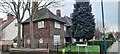
Introduction
This page details the photographs taken nearby to Radbourne Road, NG2 4BX by members of the Geograph project.
The Geograph project started in 2005 with the aim of publishing, organising and preserving representative images for every square kilometre of Great Britain, Ireland and the Isle of Man.

There are currently over 7.5m images from over14,400 individuals and you can help contribute to the project by visiting https://www.geograph.org.uk
Image Map
Images are licensed for reuse under creativecommons.org/licenses/by-sa/2.0
Notes
- Clicking on the map will re-center to the selected point.
- The higher the marker number, the further away the image location is from the centre of the postcode.
Image Listing (170 Images Found)
Images are licensed for reuse under creativecommons.org/licenses/by-sa/2.0
Image
Details
Distance
1
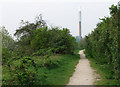
Once a railway
This was, until the 1960s, the route built by the Ambergate, Nottingham, Boston & Eastern Junction (later the Great Northern) Railway in the 1850s, leading to its London Road terminus and, after 1900, via London Road High Level, to Nottingham Victoria. Trains to and from Grantham and holiday specials carrying Nottinghamians to the East Coast used this line. The chimney of Eastcroft Incinerator is straight ahead, on the other side of the remaining railway, the Midland route to Newark and Lincoln (which has been used by Grantham trains, which branch off at Netherfield, since Victoria Station closed).
Image: © John Sutton
Taken: 15 Apr 2011
0.04 miles
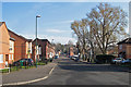
2
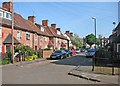
Sneinton: the end of Cosby Road
A small estate of inter-wars council houses south of Colwick Road. Beyond are newer houses on Ivatt Drive, built on railway land, and further away the chimney of Eastcroft Incinerator.
Image: © John Sutton
Taken: 16 May 2016
0.05 miles
3
Sneinton: Beckford Road
A small estate of inter-wars council houses south of Colwick Road.
Image: © John Sutton
Taken: 16 May 2016
0.06 miles
4
Closed footpath near Trent Lane
The footpath from Manvers Street and Meadow Lane which runs on the trackbed of the Great Northern Railway Nottingham-Grantham line is currently closed while a new footbridge is being built at Trent Lane - part of the reconfiguration of the track and signalling of Nottingham Midland Station and its approaches. Colwick Woods are on the skyline.
Image: © John Sutton
Taken: 13 Jun 2013
0.07 miles
5
Colwick Road houses at Hoten Road junction
There is an Ordnance Survey benchmark Image on the side of the nearest house at its front corner
Image: © Roger Templeman
Taken: 28 Jan 2022
0.07 miles
6
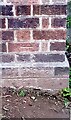
Benchmark on #32 Colwick Road (Hoten Road face)
Ordnance Survey cut mark benchmark levelled at 25.170m above Newlyn Datum verified 1962
Image: © Roger Templeman
Taken: 28 Jan 2022
0.07 miles
7
A new view of Sneinton
A view from the new railway footbridge at Trent Lane, with St Stephen's Church on the skyline to the left and Green's Windmill above the trees on the right.
Image: © John Sutton
Taken: 22 Aug 2013
0.07 miles
8
Sneinton: the north end of Meadow Lane
Looking towards Colwick Road from the corner of Ivatt Drive on a bright spring morning.
Image: © John Sutton
Taken: 13 Apr 2016
0.09 miles
9
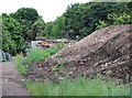
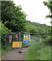
Footbridge construction at Trent Lane
The foot crossing is being replaced by a footbridge as part of the reconfiguration and resignalling of Nottingham Midland Station and its approaches. Straight ahead are the abutments of the girder bridge which once carried the Great Northern Railway line from Grantham to Nottingham (shown from other angles in Image] and Image]) over the Midland's Lincoln line. The spoil to the right is from the parts of the nearer abutment which have been demolished. The crossing and associated footpaths are currently closed. This is a view through the barrier shown in Image
Image: © John Sutton
Taken: 13 Jun 2013
0.09 miles
10
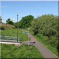
Sneinton Greenway
A system of paths on former Great Northern Railway land. The view is from the new footbridge over the railway at Trent Lane.
Image: © John Sutton
Taken: 16 May 2016
0.09 miles