IMAGES TAKEN NEAR TO
School Lane, NEWARK, NG23 5QL
Introduction
This page details the photographs taken nearby to School Lane, NG23 5QL by members of the Geograph project.
The Geograph project started in 2005 with the aim of publishing, organising and preserving representative images for every square kilometre of Great Britain, Ireland and the Isle of Man.

There are currently over 7.5m images from over14,400 individuals and you can help contribute to the project by visiting https://www.geograph.org.uk
Image Map
Images are licensed for reuse under creativecommons.org/licenses/by-sa/2.0
Notes
- Clicking on the map will re-center to the selected point.
- The higher the marker number, the further away the image location is from the centre of the postcode.
Image Listing (31 Images Found)
Images are licensed for reuse under creativecommons.org/licenses/by-sa/2.0
Image
Details
Distance
1
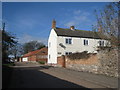
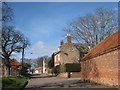
School Lane
Note the mixture of stone and brick.
Image: © Jonathan Thacker
Taken: 25 Feb 2012
0.01 miles
2
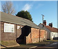
East Stoke, Notts.
The Women's Institute premises on School Lane. Opposite this window, on the other side of a T junction, is a minor lane known as Humber Lane. A minute's walk ahead, beyond the white-painted cottages is the Fosse Way (the former A46) that links Nottingham and Newark.
Image: © David Hallam-Jones
Taken: 10 Jan 2016
0.03 miles
3
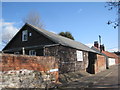
East Stoke Women's Institute Hall
The centre of social life in the village.
Image: © Jonathan Thacker
Taken: 25 Feb 2012
0.03 miles
4
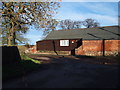
East Stoke, Notts.
With Humber Lane behind the photographer, the Women's Institute hall is seen ahead at the junction with School Lane on the right and Church Lane on the left. Within a minute or so, on foot, the junction with the Fosse Way linking Nottingham and Newark (i.e. the former A46) can be reached. Conversely, a five minute walk left, along Church Lane, leads to Stoke Hall, a Grade II-listed function venue.
Image: © David Hallam-Jones
Taken: 10 Jan 2016
0.04 miles
5
School Lane (2)
As peaceful as it looks now that the A46 no longer thunders past the lane end.
Image: © Jonathan Thacker
Taken: 25 Feb 2012
0.04 miles
6
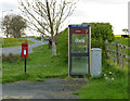
East Stoke postbox ref NG23 146 and telephone kiosk
Standard EIIR lampbox on post; the telephone kiosk is still in service.
Image: © Alan Murray-Rust
Taken: 13 Apr 2014
0.06 miles
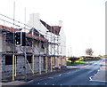
7
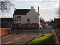
East Stoke, Notts.
Most of this small village lies behind the photographer on School Lane and Church Lane (each a continuation of the other). This view - from School Lane - however, indicates how the village is bisected by the former A46 road (now known as either the Foss Way or the Fosse Way). The new dual carriageway version of the A46 runs parallel with the Foss/Fosse Way 2-3 mins along the road seen ahead, i.e. Moor Lane (although no access is possible to the new road from Moor Lane). Nottingham is reached by taking a right-hand turning at this junction and Newark via a left-hand turn. The building on the corner, that is currently being redeveloped into residential units, was formerly The Pauncesfot Arms public house. More recently it saw service as a none-to-successful Indian restaurant.
Image: © David Hallam-Jones
Taken: 10 Jan 2016
0.06 miles
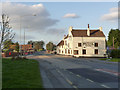
9
East Stoke, Notts.
The view towards Nottingham along the former A46 road (now known as the Foss Way, a.k.a. the Fosse Way) as it passes through the village of East Stoke. The heart of this small village is on the photographer's right. The building being extended and renovated was formerly the Pauncesfot Arms, that was more recently a less-than successful Indian restaurant. It is currently being changed into residential units. The one-time public house was named in honour of Julian Pauncefote, (1828 -1902). Between 1874-99, this German-born, naturalised British citizen was a barrister, a judge and a diplomat. He was Permanent Under-Secretary of State for Foreign Affairs between 1882-89 and as such he was appointed Envoy Extraordinary and Minister Plenipotentiary to the United States, an office that was eventually upgraded to that of Ambassador to the United States in 1893. He was elevated to the peerage as the 1st Baron Pauncefote in 1899. He died in office in 1902.
Image: © David Hallam-Jones
Taken: 10 Jan 2016
0.07 miles
10
Former A46 at East Stoke
The old Pauncefoote Arms public house became an Indian restaurant which itself has ceased trading, possibly as a result of the loss of through traffic on the road. The traffic lights for the pedestrian crossing are really no longer justified.
Image: © Alan Murray-Rust
Taken: 13 Apr 2014
0.07 miles