IMAGES TAKEN NEAR TO
Common Lane, MANSFIELD, NG19 8RZ
Introduction
This page details the photographs taken nearby to Common Lane, NG19 8RZ by members of the Geograph project.
The Geograph project started in 2005 with the aim of publishing, organising and preserving representative images for every square kilometre of Great Britain, Ireland and the Isle of Man.

There are currently over 7.5m images from over14,400 individuals and you can help contribute to the project by visiting https://www.geograph.org.uk
Image Map
Images are licensed for reuse under creativecommons.org/licenses/by-sa/2.0
Notes
- Clicking on the map will re-center to the selected point.
- The higher the marker number, the further away the image location is from the centre of the postcode.
Image Listing (16 Images Found)
Images are licensed for reuse under creativecommons.org/licenses/by-sa/2.0
Image
Details
Distance
1
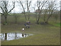
Horses at Windy Ridge
The farm with water-logged fields, seen from the Archaeological Way, west of Pleasley Park.
Image: © Peter Barr
Taken: 8 Jan 2013
0.04 miles
2
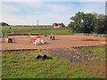
Horse paddocks near Pleasley Park
Looking west to a training area and paddocks just south of the B6407.
Image: © Trevor Rickard
Taken: 2 Oct 2010
0.04 miles
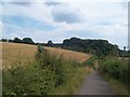
3
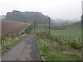
Road to Pleasley Park
This track is now a bridleway but the 1940s OS map shows it as a road which lead to Pleasley Park and the cotton mills there. Image The stonework to the left of the track is an old railway bridge support.
Image: © Michael Patterson
Taken: 12 Sep 2006
0.06 miles
4
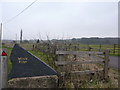
Gateway to Windy Ridge
Entrance to a country dwelling, on the B6407 between Pleasley and Upper Langwith.
Image: © Peter Barr
Taken: 8 Jan 2013
0.07 miles
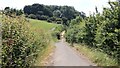
5
The Archaeological Way near Pleasley Mills
Bridleway and long-distance footpath seen here from the B6407 Road as the track begins its descent into Pleasley Vale. The stone pillar on the right of picture in front of the trees marks the route of a defunct railway line.
Image: © Jonathan Clitheroe
Taken: 26 Jul 2014
0.10 miles
6
Forge Lane
Just behind the viewpoint Forge Lane crosses the B6407, the Pleasley to Shirebrook road. Ahead the lane leads to Pleasley Vale.
This metalled surface is one of two short sections of Forge Lane that remain in this condition, the other section being adjacent to some industrial units near Pleasley Vale.
Although this is now a bridleway an OS map dated 1937-61 from the National Library of Scotland https://maps.nls.uk/geo/explore/side-by-side/#zoom=16&lat=53.1841&lon=-1.2291&layers=10&right=osm shows Forge Lane as being a single-track road between the B6407 and Pleasley Vale.
***
See also this photograph by Michael Patterson:- Image, which shows the same section of Forge Lane but which was taken some twelve years earlier.
Image: © Alan Walker
Taken: 3 Jul 2018
0.10 miles
7
Abutments of old railway bridge on Archaeology Way
Image: © Chris Morgan
Taken: 2 Jun 2014
0.10 miles
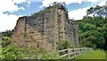
8
Remains of a railway bridge on Forge Lane
Image: © John Slater
Taken: 1 Aug 2013
0.10 miles
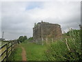
9
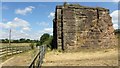
Old railway bridge abutment
This abutment is all that remains of a bridge that once carried the Leen Valley Extension Railway over Image
The Leen Valley Extension Railway was built by the Great Northern Railway to provide the company with access to the coal workings in the area. The railway ran from Kirkby South Junction to Langwith Junction.
Reference:- https://www.pastscape.org.uk/hob.aspx?hob_id=316103 .
An OS map dated 1937-61 from the National Library of Scotland https://maps.nls.uk/geo/explore/side-by-side/#zoom=15&lat=53.1853&lon=-1.2347&layers=10&right=osm shows the point at which the railway crossed Forge Lane.
Today the old track-bed provides the basis for the Image, including a branch line that ran to the Silverhill and Teversal collieries and now forms the Image
***
See also these photographs by
Chris Morgan:- Image,
James Hill:- Image and
John Slater:- Image
Image: © Alan Walker
Taken: 3 Jul 2018
0.10 miles
10
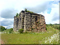
Remains of Bridge Pillar, Pleasley
This is what appears to be the remains of a dismantled railway bridge. The 1:50,000 Modern Day Landranger™ map clearly shows the "dismtd rly" line that crosses over this area.
Image: © James Hill
Taken: 16 Jun 2007
0.11 miles