IMAGES TAKEN NEAR TO
Lower Oakham Way, MANSFIELD, NG18 5BZ
Introduction
This page details the photographs taken nearby to Lower Oakham Way, NG18 5BZ by members of the Geograph project.
The Geograph project started in 2005 with the aim of publishing, organising and preserving representative images for every square kilometre of Great Britain, Ireland and the Isle of Man.

There are currently over 7.5m images from over14,400 individuals and you can help contribute to the project by visiting https://www.geograph.org.uk
Image Map
Images are licensed for reuse under creativecommons.org/licenses/by-sa/2.0
Notes
- Clicking on the map will re-center to the selected point.
- The higher the marker number, the further away the image location is from the centre of the postcode.
Image Listing (11 Images Found)
Images are licensed for reuse under creativecommons.org/licenses/by-sa/2.0
Image
Details
Distance
1
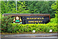
Entrance to Mansfield Brewery
Brewing stopped in Mansfield in 2000 after the brewery was taken over by Wolverhampton and Dudley Breweries and brewing moved to Wolverhampton. The original brewery site closed in 2001 and the current site is now only a distribution depot. The 'Mansfield' now being owned by Marstons plc.
Image: © Pete Wise
Taken: 7 Jul 2009
0.08 miles
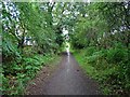
3
Bleak Hills Lane, Mansfield, Notts.
Observers standing here are facing the start of (or the conclusion of) the asphalted end of Bleak Hills Lane, a road that runs from Sheepbridge Road and High Oakham Hill to this point. Current maps still identify this property as "Beeton's Cottage", although it looks as though this has been replaced by this large replacement called Bleak Hills House. On the right, behind the 'turning place', are a set of locked 7ft high mesh/grid gates
and on the other side of which is a grassed track that has the potential to link up with Cauldwell Road via Lower Oakham, although who has rights of access is not clear. Behind the photographer is a footpath that connects with Hamilton Way in the vicinity of a 'light industrial' zone in the Bleak Hills area.
Image: © David Hallam-Jones
Taken: 16 Jun 2013
0.17 miles
4
Bleak Hills Lane, Mansfield, Notts.
Observers standing here are facing the end of Bleak Hills Lane that joins Sheepbridge Road and High Oakham Hill. The asphalted part of Bleak Hills Lane end here at a point in the road where it is possible to turn a vehicle, i.e. on the right of this right. Current maps still identify the property on this site as "Beeton's Cottage" although it looks as though this has been replaced by this large replacement called Bleak Hills House. Off this picture to the right, behind the 'turning place', are a set of locked 7ft high mesh/grid gates
and on the other side of which is a grassed track that has the potential to link up with Cauldwell Road, although who has rights of access is not made clear. Behind the photographer is a footpath that connects with Hamilton Way in the vicinity of a 'light industrial' zone in the Bleak Hills area.
Image: © David Hallam-Jones
Taken: 16 Jun 2013
0.17 miles
5
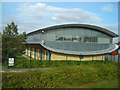
Futuristic Office Building
The iCentre on Oakham Business Park
Image: © Antony Dixon
Taken: 23 Sep 2011
0.21 miles
6
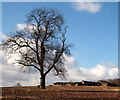
Cauldwell Brook Vicinity, Mansfield, Notts.
A solitary tree and a cluster of derelict farm buildings to the east of Lower Oakham Way, i.e. Oakham Business Park is situated a short distance behind the buildings. This is a view from the boundary of a field parallel with Cauldwell Brook. From this point the brook continues to the right towards a series of fishing ponds accessible from Bleak Hills Lane.
Image: © David Hallam-Jones
Taken: 27 Feb 2015
0.22 miles
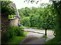
7
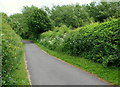
Bleak Hills Lane, Mansfield, Notts.
A view of a section of Bleak Hills Lane towards Bleak Hills Dam (and private fishing ponds) as seen from the site of a former property called Beeston's Cottage. This plot of land on which this earlier property was located now houses a much larger replacement house called Bleak Hills House. This is situated a dozen or so paces behind the photographer, as is a "footpath only" continuation of this thoroughfare that leads to Hamilton Way and the Bleak Hills area light industry zone. Locals have confirmed that this lane was also known as Harvey's Lane in the 1940s.
Image: © David Hallam-Jones
Taken: 16 Jun 2013
0.22 miles
8
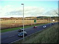
Industrial development land
This land was prepared for industrial development some years ago, but not much has happened since. However, two men in high-visibility jackets (just visible in the far left of the photo) seemed to be taking measurements, so maybe something is afoot. Buildings in Oakham Business Park are just in the photo (left background among the trees) and Cauldwell Wood on the right. A617 in the foreground.
Image: © Antony Dixon
Taken: 5 Jan 2012
0.24 miles
9
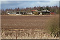
Cauldwell Brook Vicinity, Mansfield, Notts.
The rear of a cluster of run-down farm buildings visible from a bull-rush filled pond visible at the foot of this photograph. The pond is a build-up of water formed by Cauldwell Brook passing through it. It is difficult to tell whether the farm-house associated with the farm is still in use because the farm track leading to the front of the premises, i.e. on the other side of the farm, off Bleak Hills Lane (to the right of this picture), is securely protected by a 7ft high security gate. The land ahead has been used to grow corn-on-the-cob recently. According to maps a Business Park exist in the distance in the Lower Oakham area. Cauldwell Wood lies 2-3 minutes walk away behind the photographer.
Image: © David Hallam-Jones
Taken: 27 Feb 2015
0.24 miles
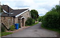
10
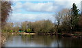
Bleak Hills Lane, Mansfield, Notts.
Having passed the under the A617 a mile or so further back, and then along the southern edge of Cauldwell Wood, Cauldwell Brook now flows through a series of fishing lakes situated on either side of Bleak Hills Lane as it continues its northerly journey towards Mansfield. These are private fishing club lakes and the club-house is visible ahead.
Image: © David Hallam-Jones
Taken: 27 Feb 2015
0.25 miles