IMAGES TAKEN NEAR TO
Nottingham Road, MANSFIELD, NG18 4SG
Introduction
This page details the photographs taken nearby to Nottingham Road, NG18 4SG by members of the Geograph project.
The Geograph project started in 2005 with the aim of publishing, organising and preserving representative images for every square kilometre of Great Britain, Ireland and the Isle of Man.

There are currently over 7.5m images from over14,400 individuals and you can help contribute to the project by visiting https://www.geograph.org.uk
Image Map
Images are licensed for reuse under creativecommons.org/licenses/by-sa/2.0
Notes
- Clicking on the map will re-center to the selected point.
- The higher the marker number, the further away the image location is from the centre of the postcode.
Image Listing (35 Images Found)
Images are licensed for reuse under creativecommons.org/licenses/by-sa/2.0
Image
Details
Distance
1
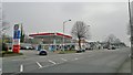
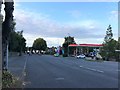
A60 Nottingham Road
A section previously popular with the motortrade. Possibly not for much longer as one site may be about to become a small housing development. Watch this space.
Image: © Chris Morgan
Taken: 31 Mar 2014
0.02 miles

3
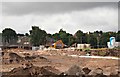
Robin Down's Hill Vicinity, Mansfield, Notts.
Housing construction on a brown field site on the opposite side of the road to the entrances into Nottingham Road Cemetery, i.e. on the east side of the A60. This view is from a footpath linking Nottingham Road and The Oaks (a residential road). The older houses behind the mechanical digger seem likely to be on Robin Down Lane. In 1767, a half-witted travelling busker called Robin Down was playing his flute in the town. A group of boys tormented him to the point where he stabbed one of them. The boy died and Robin Down was apprehended and taken to Nottingham to be tried. In a bid to prove his sanity, the judge, offered Robin Down a choice of two coins, one silver and one gold. As a result of choosing the gold coin because it was 'the shiniest and the most valuable', the judge deemed that he was sane enough to stand trial. He was sentenced and subsequently hanged in Nottingham. His dismembered body was hung on chains at this spot and Robin Down Hill (and Lane) still exist today as a reminder of these events.
Image: © David Hallam-Jones
Taken: 16 Jul 2017
0.05 miles
4
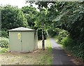
Mansfield Road Cemetery Vicinity, Mansfield, Notts.
This path commences immediately behind the photographer on Nottingham Road (the A60), opposite Mansfield's Nottingham Road Cemetery. A few hundred metres ahead lies a residential area sandwiched between Nottingham Road and Berry Hill Park (a municipal park).
Image: © David Hallam-Jones
Taken: 16 Jul 2017
0.05 miles
5
Footpath off Nottingham Road, Mansfield
Leading to Gordon Brae.
Image: © Richard Vince
Taken: 15 Aug 2020
0.06 miles
6
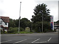
A60 Nottingham Road in Mansfield
One of the main arterial roads into the town.
Image: © Jonathan Clitheroe
Taken: 12 Sep 2020
0.07 miles
7
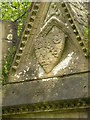
Mansfield Cemetery, Wildman memorial, detail
Dated 1859, in high Victorian Gothic style. Listed Grade II. Family arms on the eastern gable
Image: © Alan Murray-Rust
Taken: 21 Aug 2019
0.07 miles
8
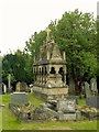
Mansfield Cemetery, Wildman memorial
Dated 1859, in high Victorian Gothic style. Listed Grade II.
Image: © Alan Murray-Rust
Taken: 21 Aug 2019
0.07 miles
9

Mansfield Cemetery, Wildman memorial, detail
Dated 1859, in high Victorian Gothic style. Listed Grade II. The main memorial inscription was on brass plaques on the inner slab which have now disappeared. There are also extensive inscriptions, now quite worn, on the base of the monument.
Image: © Alan Murray-Rust
Taken: 21 Aug 2019
0.07 miles
10
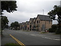
Nottingham Road, Mansfield
Descending towards the town centre from the junction with Robin Down Lane (just out of frame to the right). On the right, a development of new houses called Rockcliffe Grange is under construction.
Image: © Richard Vince
Taken: 15 Aug 2020
0.07 miles