IMAGES TAKEN NEAR TO
Blackthorn Drive, MANSFIELD, NG18 4BR
Introduction
This page details the photographs taken nearby to Blackthorn Drive, NG18 4BR by members of the Geograph project.
The Geograph project started in 2005 with the aim of publishing, organising and preserving representative images for every square kilometre of Great Britain, Ireland and the Isle of Man.

There are currently over 7.5m images from over14,400 individuals and you can help contribute to the project by visiting https://www.geograph.org.uk
Image Map
Images are licensed for reuse under creativecommons.org/licenses/by-sa/2.0
Notes
- Clicking on the map will re-center to the selected point.
- The higher the marker number, the further away the image location is from the centre of the postcode.
Image Listing (22 Images Found)
Images are licensed for reuse under creativecommons.org/licenses/by-sa/2.0
Image
Details
Distance
1
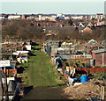
Forest Road Allotments, Mansfield, Notts.
With the town centre in the distance this is a view across allotment gardens off Forest Road (the B6030) in the direction of Baum's Lane.
Image: © David Hallam-Jones
Taken: 8 Feb 2015
0.12 miles
2

Shops and houses, Nottingham Road, Mansfield
Image: © Jonathan Thacker
Taken: 13 Jan 2022
0.14 miles
3
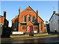
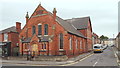
Bethel Methodist Church, Mansfield
Image: © Jonathan Thacker
Taken: 13 Jan 2022
0.17 miles
4
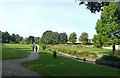
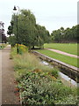
Titchfield Park, Mansfield
The River Maun has been canalised through the park. The modern 'Water Meadows' leisure complex indicates what the area would have been before urbanisation.
Image: © Alan Murray-Rust
Taken: 21 Aug 2019
0.17 miles
5
Titchfield Park, Mansfield
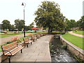
A lovely "green space" in Mansfield that has seen a recent revamp and a Green Flag award. The only fault I can pick is that the huge concrete pipes and old blue tractor that I spent many happy hours playing in and on as a child have been removed. Still, I doubt that they would have gone with the current scheme.
Image: © James Hill
Taken: 26 Aug 2007
0.18 miles
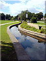
6
Mansfield, Notts.
The 'busy' River Maun making its way through Titchfield Park, its two sides being linked by several bridges. This fairly extensive plot of land has been a recreational area since 1880. It was formerly known as Nottingham Road Pleasure Grounds or The Water Meadows. It was renamed Titchfield Park in 1914, to mark the coming of age of the Duke of Portland's son, Marquis of Titchfield. This green corridor forms part of the Maun Valley Trail. Nottingham Road (the A60) semi-encompasses the park, behind and to the left of this shot.
Image: © David Hallam-Jones
Taken: 13 Sep 2013
0.18 miles
7
Mansfield, Notts.
Looking eastwards along Gedling Street. Bethel Methodist Church (formerly of the Primitive Methodist persuasion), dating from 1896, is seen here from the opposite side of the Nottingham-Mansfield Road (the A60).
Image: © David Hallam-Jones
Taken: 13 Sep 2013
0.18 miles
8
Mansfield, Notts.
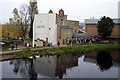
One of several bridges that crosses the ‘busy’ River Maun in Titchfield Park. In 1914 it was renamed, from “Nottingham Road Pleasure Grounds” (a.k.a. The Water Meadows), to mark the coming of age of the Duke of Portland's son, the Marquis of Titchfield. Opened in 1881, today the park offers ornamental gardens, playground areas, a multi-purpose games area, a pavilion, a performance area, pétanque pistes and a meadow area for informal recreation. The riverside walk forms part of the Maun Valley Trail.
Image: © David Hallam-Jones
Taken: 13 Sep 2013
0.18 miles
10
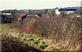
Towards Forest Avenue, Mansfield, Notts.
With Littleworth (< road name) a couple of paces behind the photographer, this public footpath continues - parallel with a playing field belonging to King Edward's Primary School (NB this is the school's boundary hedge) - until it reaches Forest Avenue. One of Mansfield Town Football Club's stands can be seen on the left.
Image: © David Hallam-Jones
Taken: 8 Feb 2015
0.19 miles