IMAGES TAKEN NEAR TO
Ratcliffe Gate, MANSFIELD, NG18 2JA
Introduction
This page details the photographs taken nearby to Ratcliffe Gate, NG18 2JA by members of the Geograph project.
The Geograph project started in 2005 with the aim of publishing, organising and preserving representative images for every square kilometre of Great Britain, Ireland and the Isle of Man.

There are currently over 7.5m images from over14,400 individuals and you can help contribute to the project by visiting https://www.geograph.org.uk
Image Map
Images are licensed for reuse under creativecommons.org/licenses/by-sa/2.0
Notes
- Clicking on the map will re-center to the selected point.
- The higher the marker number, the further away the image location is from the centre of the postcode.
Image Listing (167 Images Found)
Images are licensed for reuse under creativecommons.org/licenses/by-sa/2.0
Image
Details
Distance
2

The Brown Cow - pub garden
A pleasant space to enjoy a drink and relax - especially on a sunny day. The pub is located on Ratcliffe Gate.
Image: © Stephen McKay
Taken: 23 Jul 2016
0.02 miles
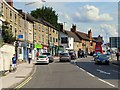
3

Ratcliffe Gate, Mansfield
The Brown Cow is an Everards pub offering a range of cask ales from Everards and other breweries. There is a pleasant beer garden at the rear. Ratcliffe Gate is part of the A6191.
Image: © Stephen McKay
Taken: 23 Jul 2016
0.02 miles
4

Ratcliffe Gate, Mansfield
A substantial area of yellow hatching marks the junction between Ratcliffe Gate (A6191), Great Central Road (leading off to the right in the foreground), and Newgate Lane (opposite). The 'Great Central Road' name is a reminder of Mansfield's largely forgotten 'other' railway that passed over Ratcliffe Gate here; it was closed completely in 1966 and little trace now remains.
Image: © Stephen McKay
Taken: 23 Jul 2016
0.05 miles
5
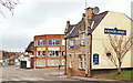
Ratcliffe Gate, Mansfield, Notts.
The Kings Arms public house is seen dominating this corner site at its junction with Newgate Street. The town centre lies ahead. After a spell in Newgate Lane, in 1914 Mansfield Town Football Club moved to a large grassed area south of Ratcliffe Gate, that gloried in the name of "The Prairie" due to this being a wide open space.
Image: © David Hallam-Jones
Taken: 7 Feb 2016
0.05 miles
6
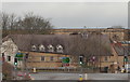
Town Mill, Mansfield, Notts.
A view of the Grade II-listed Town Mill, Bridge Street, i.e. on the opposite side of St Peter's Way. This watermill, built in the 1740s, used the River Maun (behind it) as its source of power. Originally a corn and malt mill, it was converted into a cotton mill in 1795 following the onset of the Industrial Revolution. Following a fire, the two uppermost storeys were demolished and at some point it served as a warehouse until it was restored in the late C20th. It reopened as “The Town Mill” public house & function venue in 2002. It is currently empty, i.e January 2017.
A former water mill of c.1775, it was powered by the River Maun. It was restored and converted in the late C20th and has seen service as a public house and a discotheque. It is currently disused and boarded up.
Image: © David Hallam-Jones
Taken: 7 Feb 2016
0.07 miles
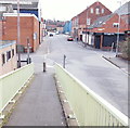
7
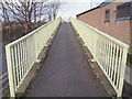
Pelham Street, Mansfield, Notts.
The fact that Pelham Street is now a cul-de-sac is evident from the left-hand side of the picture. In the past - before the St Peter's Way (i.e. the A60/A6006) was constructed - perhaps it continued ahead? This footbridge carries users over this dual carriageway to Rock Valley, the area where the Metal Box Company's huge site could once be found.
Image: © David Hallam-Jones
Taken: 7 Feb 2016
0.08 miles
8
Pelham Street, Mansfield, Notts.
A view along Pelham Street from the footbridge that carries users from Rock Valley, over the St Peter's Way dual carriageway (i.e. the A60/A6006). During the early part of the C19th Mansfield’s "lock-up" was at the Pelham Street end of Elm Tree Yard. Detainees were confined there until the magistrate’s next courthouse session elsewhere in the town. If convicted, prisoners were then marched to the local prison in Southwell some 5 miles away. On 7 April 1952 a new Telephone Exchange was officially opened in Pelham Street by the Mayor, Mr. German Abbott. At present the street seems to be host to both residential properties and commercial premises. The Recreation Street junction can be seen on the left and the Elm Tree Street one to the right.
Image: © David Hallam-Jones
Taken: 7 Feb 2016
0.09 miles
9
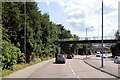
Mansfield, Footbridge over St Peter's Way
Image: © David Dixon
Taken: 4 Aug 2014
0.09 miles
10
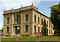
Bridge Street Methodist Church, Mansfield
Dated 1864, in Italianate style, Listed Grade II.
Image: © Alan Murray-Rust
Taken: 21 Aug 2019
0.09 miles