IMAGES TAKEN NEAR TO
Clifton Place, MANSFIELD, NG18 1PN
Introduction
This page details the photographs taken nearby to Clifton Place, NG18 1PN by members of the Geograph project.
The Geograph project started in 2005 with the aim of publishing, organising and preserving representative images for every square kilometre of Great Britain, Ireland and the Isle of Man.

There are currently over 7.5m images from over14,400 individuals and you can help contribute to the project by visiting https://www.geograph.org.uk
Image Map
Images are licensed for reuse under creativecommons.org/licenses/by-sa/2.0
Notes
- Clicking on the map will re-center to the selected point.
- The higher the marker number, the further away the image location is from the centre of the postcode.
Image Listing (215 Images Found)
Images are licensed for reuse under creativecommons.org/licenses/by-sa/2.0
Image
Details
Distance
1
West Hill Drive, Mansfield, Notts.
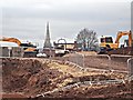
West Hill Drive (ahead) is seen from one of several building site entrances. Inside this fence work continues apace on a project to build new homes for over-55s on the former Mansfield General Hospital site. This now-demolished hospital began with five beds in the early C19th and boasted 108 beds by 1890. Eric Sykes, the comedian, opened the last ward extension in 1950, a wing containing 60 beds. The hospital finally closed its doors in 1992, once the new King's Mill Hospital was opened, after which time it stood empty for over 20 years. West Hill Drive empties out - in both directions - into Chesterfield Road South (i.e. the A6009).
Image: © David Hallam-Jones
Taken: 7 Jan 2017
0.01 miles
2
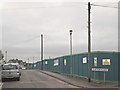
West Hill Drive, Mansfield, Notts.
The site of the former General Hospital. Behind the fence work continues apace on a project to build new homes for over-55s. This now-demolished hospital began with five beds in the early C19th and boasted 108 beds by 1890. Eric Sykes, the comedian, opened the last extension in 1950, a wing containing 60 beds. The hospital finally closed its doors in 1992, after the new King's Mill Hospital had been opened. It then stood empty for over 20 years. West Hill Drive empties out - at both ends - into Chesterfield Road South (i.e. the A6009).
Image: © David Hallam-Jones
Taken: 7 Jan 2017
0.02 miles
3
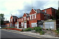
Former Hospital, Mansfield, Notts.
This hospital on West Hill Drive started with five beds in the early C19th and was known as The Mansfield General Hospital. By 1890 it boasted 108 beds. Finally, Eric Sykes, the comedian, opened the last ward extension in 1950, a wing containing 60 beds. The hospital closed its doors in 1992, after King's Mill Hospital opened and it has now stood empty and uncared for over 20 years. Recently however, the Council have announced plans to build housing on the site. The other side of the road is already occupied by private housing.
Image: © David Hallam-Jones
Taken: 16 Jun 2013
0.03 miles
4
West Hill Drive, Mansfield, Notts.
Construction work on the site of the former Mansfield General Hospital. This project is an £8.5m residential complex of 42 x one and two bedroom apartments, plus 12 bungalows. The accommodation will be for the over-55 year olds and is to be set around a landscaped village green. Completion of the project is anticipated to be in November 2017. In the distance is church of St John with St Mary on the other side of the A6009 (a.k.a. Chesterfield Road South). The church tower is approximately 80 feet in height and the spire about 100 feet.
Image: © David Hallam-Jones
Taken: 7 Jan 2017
0.03 miles
5
West Hill Drive Vicinity, Mansfield, Notts.
The rubble in the foreground is all that remains of Mansfield's former general hospital, whilst providing the backdrop is the Mansfield Business Centre, Ashfield Avenue. Addendum: Planning permission for the construction of an £8.5m residential complex of 42 one and two bedroom apartments + 12 bungalows was granted in April 2016. This accommodation is to be for the over-55s, and it will be set around a landscaped village green. The construction period for the scheme is anticipated to be June 2016-November 2017.
Image: © David Hallam-Jones
Taken: 15 Jan 2016
0.03 miles
7
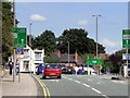
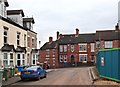
Inner Ring Road (A6009/A6191), Mansfield
The A6191 runs for 5 miles between Mansfield and Rainworth. It follows what was originally the route of the A617 through Mansfield. The road was redesignated to A6191 after the completion of the MARR (Mansfield Ashfield Regeneration Route) to the south of the town, which took over the A617 number in 2004. Just before reaching the town centre, the A6191 mutiplexes with the A6009, otherwise known as the Inner Ring Road.
The A6009 is a circular route, avoiding the main business district of Mansfield, Nottinghamshire. It has a 40 mph limit throughout, and is a mixture of single and dual carriageway road. It should not be confused with "The Mansfield Circuit", which is a one way system that lies inside the Inner Ring Road.
Image: © David Dixon
Taken: 4 Aug 2014
0.04 miles
8
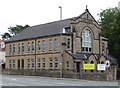
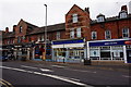
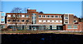
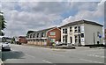
Mansfield - Christian Community Centre
On Woodhouse Road.
Image: © Dave Bevis
Taken: 17 Sep 2013
0.05 miles
9
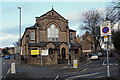
A60/Terrace Road Junction, Mansfield, Notts.
The combined Church of God of Prophecy and Mansfield Christian Community Centre occupying a triangular plot of land between Terrace Road to the right and the A60 (Woodhouse Road) on the left. The blue car descending towards the photographer has come from the Mansfield Woodhouse area.
Image: © David Hallam-Jones
Taken: 8 Jan 2015
0.06 miles