IMAGES TAKEN NEAR TO
Pleasley Road, SUTTON-IN-ASHFIELD, NG17 3JP
Introduction
This page details the photographs taken nearby to Pleasley Road, NG17 3JP by members of the Geograph project.
The Geograph project started in 2005 with the aim of publishing, organising and preserving representative images for every square kilometre of Great Britain, Ireland and the Isle of Man.

There are currently over 7.5m images from over14,400 individuals and you can help contribute to the project by visiting https://www.geograph.org.uk
Image Map
Images are licensed for reuse under creativecommons.org/licenses/by-sa/2.0
Notes
- Clicking on the map will re-center to the selected point.
- The higher the marker number, the further away the image location is from the centre of the postcode.
Image Listing (102 Images Found)
Images are licensed for reuse under creativecommons.org/licenses/by-sa/2.0
Image
Details
Distance
2
Peartree Lane
This photograph was taken at the southern end of Peartree Lane adjacent to a Image (on the left) and a few metres in from the Teversal to Pleasley road near Teversal (behind the viewpoint).
For another photograph taken some 150m ahead, click here:- Image
Image: © Alan Walker
Taken: 22 Dec 2016
0.13 miles
3
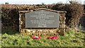
Memorial stone
This stone is in the Image adjacent to Image and reads:-
THIS
RECREATION GROUND
IS GIVEN BY
ELISABETH COUNTESS OF CARNARVON
FOR THE USE OF THIS
VILLAGE
AND FOR THE ABIDING REMEMBRANCE
OF THE GALLANT YOUNG SOLDIERS
OF TEVERSAL
1914 - 1918
Image: © Alan Walker
Taken: 15 Feb 2018
0.13 miles
4
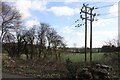
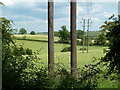
Power lines
This easterly facing photograph, taken from the Teversal Trail, shows power lines at a point where they change direction as they make their way, behind the viewpoint, toward Fackley. Ahead the lines pass Dawgates Farm on their way to the outskirts of Mansfield.
When the photograph was taken, shrubbery and undergrowth below the route of the cables had fairly recently been cleared.
See also this photograph by Andrew Hill:- Image
Image: © Alan Walker
Taken: 15 Feb 2018
0.13 miles
5
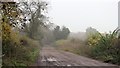
Peartree Lane
This photograph was taken at a point approaching a bridge over Image
For another photograph of the lane taken some 40m ahead, click here:- Image
For a photograph of the lane taken some 150m behind the viewpoint, click here:- Image
Image: © Alan Walker
Taken: 3 Nov 2015
0.15 miles
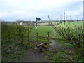
6
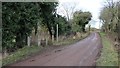
Peartree Lane
The photograph shows an access point onto the Image from Peartree Lane.
Just a few metres ahead Image crosses the trail via a three arch, brick bridge.
For a photograph of the lane taken some 40m behind the viewpoint, click here:- Image
- - -
An OS map revised in 1875 and published in 1877 names the lane as Marker Lane. By 1900 the name had changed to Peartree Lane.
Image: © Alan Walker
Taken: 15 Feb 2018
0.15 miles
7
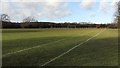
Fields and line of power poles
View from the former railway line north of Teversal.
Image: © Andrew Hill
Taken: 9 Jun 2011
0.15 miles
8
Recreation ground
This is the Pear Tree Lane recreation ground and is the home of AFC Carnarvon.
The ground was given to the village, as inscribed on a Image adjacent to the entrance on Image, by Elisabeth Countess of Carnarvon http://discovery.nationalarchives.gov.uk/details/c/F54946 .
Image: © Alan Walker
Taken: 15 Feb 2018
0.15 miles
9
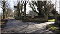
Buttery Lane and the entrance drive to Teversal Manor
The photograph shows Buttery Lane looking in the direction toward Skegby and, on the right, the entrance drive to driveway to Teversal Manor https://en.wikipedia.org/wiki/Teversal_Manor .
See also this photograph:- Image
Over the wall, and to the right is St. Katherine's Church https://en.wikipedia.org/wiki/St_Katherine%27s_Church,_Teversal , http://southwellchurches.nottingham.ac.uk/teversal/hhistory.php , http://www.nottshistory.org.uk/articles/tts/tts1904/summer/teversal1.htm .
Image: © Alan Walker
Taken: 15 Feb 2018
0.16 miles
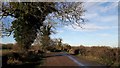
10
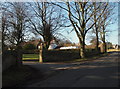
Teversal, Sutton-in-Ashfield NG17, Notts
The entrance to a drive that leads to the gates of Teversal Manor is seen here from Buttery Lane, that leads to the centre of this small village. Faulkes (2004) has noted that "the suffix 'sal' is from an old Saxon word meaning a seat or dwelling, mansion, palace or hall", an indication that an early landowner had a dwelling or residence here. Behind the photographer Buttery Lane joins the B6014 road in the Skegby area.
Image: © David Hallam-Jones
Taken: 2 Mar 2013
0.16 miles