IMAGES TAKEN NEAR TO
Moor Road, NOTTINGHAM, NG15 8EP
Introduction
This page details the photographs taken nearby to Moor Road, NG15 8EP by members of the Geograph project.
The Geograph project started in 2005 with the aim of publishing, organising and preserving representative images for every square kilometre of Great Britain, Ireland and the Isle of Man.

There are currently over 7.5m images from over14,400 individuals and you can help contribute to the project by visiting https://www.geograph.org.uk
Image Map
Images are licensed for reuse under creativecommons.org/licenses/by-sa/2.0
Notes
- Clicking on the map will re-center to the selected point.
- The higher the marker number, the further away the image location is from the centre of the postcode.
Image Listing (30 Images Found)
Images are licensed for reuse under creativecommons.org/licenses/by-sa/2.0
Image
Details
Distance
1
Papplewick Grange, NG15
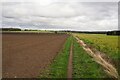
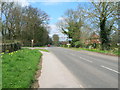
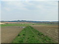
Although large in size this appears to be the former lodge house at the entrance to the former Papplewick Grange. This private road, albeit a track, is a left hand turning off Moor Road, (the B683) seen here heading towards Papplewick. Behind a boundary hedge to the photographer's right are fields currently in use for arable purposes. This rectangular area, near the boundary with the Griffin's Head pub area and Forest Road (the B6011), is referred to on some maps as Papplewick Moor and it appears that it hosted the Royal Flying Corps Papplewick Moor Station and RAF Papplewick Moor Station between October 1916 - November 1945.
Image: © David Hallam-Jones
Taken: 17 Nov 2012
0.06 miles
2
Papplewick Grange, NG15
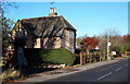
These gateposts and gates at the entrance to this private drive leading to the site once occupied by the former Papplewick Grange, off Moor Lane (the B683), appears to be the original ones. The once large mansion was the home of George Robinson, the owner of several cotton mills in Papplewick and following his death, his son James Robinson continued to live there, even after the mills had been sold. The Grange survived the demolition of Grange Mill but was finally pulled down in 1932. Later, "Papplewick Lido", a leisure complex, was built in the grounds. The lido was demolished in 1995 and a cluster of modern houses now occupy part of the site. Beyond the boundary hedge behind the photographer are fields currently being used for arable purposes. This rectangular area, that extends near the boundary of the Griffin's Head pub and Forest Road (the B6011), is referred to on some maps as Papplewick Moor and it appears that it hosted the Royal Flying Corps Papplewick Moor Station and RAF Papplewick Moor Station between October 1916-45.
Image: © David Hallam-Jones
Taken: 17 Nov 2012
0.06 miles
3
Papplewick village sign
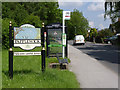
On Moor Road, this version refers to the ponds along the River Leen. Papplewick has chosen to have more than one design of the new sign.
Image: © Alan Murray-Rust
Taken: 1 Jun 2014
0.08 miles
6
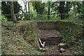
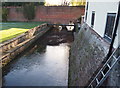
Blocked culvert
At the southern end of the Papplewick Trail, this excavated culvert entrance presumably would have carried the mill races under Moor Road?
Image: © David Lally
Taken: 27 Oct 2021
0.12 miles
7
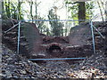
Nottingham, NG15 - Papplewick
George Robinson owned a number of cotton mills in this area during the late 18th century and sufficient water power had to be produced from the weak-flowing River Leen at many places along its course using a system of leats. This is a picture of some conservation work that is currently being undertaken in a wooded area off Moor Lane (the B683), near its junction with Linby Lane (the B6011) where a sluice seems to have been built to control the flow of water to a lower level.
Image: © David Hallam-Jones
Taken: 2 Dec 2012
0.12 miles
8
Papplewick, NG15 - Grange Farm Area
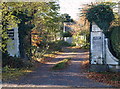
A view of the River Leen travelling in the direction of two long-demolished properties, i.e. Grange Mill and Papplewick Grange. Here the river reappears from beneath a bridge that carries the Grange Farm access track (sometimes referred to as Grange Gardens) from the farm out onto Moor Road (the B683).
Image: © David Hallam-Jones
Taken: 17 Nov 2012
0.13 miles
9
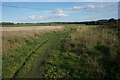
Path onto Papplewick Moor
Part of the Robin Hood Way heading towards Burntstump Hill.
Image: © Bill Boaden
Taken: 15 Oct 2022
0.13 miles