IMAGES TAKEN NEAR TO
Wigwam Lane, NOTTINGHAM, NG15 7SZ
Introduction
This page details the photographs taken nearby to Wigwam Lane, NG15 7SZ by members of the Geograph project.
The Geograph project started in 2005 with the aim of publishing, organising and preserving representative images for every square kilometre of Great Britain, Ireland and the Isle of Man.

There are currently over 7.5m images from over14,400 individuals and you can help contribute to the project by visiting https://www.geograph.org.uk
Image Map
Images are licensed for reuse under creativecommons.org/licenses/by-sa/2.0
Notes
- Clicking on the map will re-center to the selected point.
- The higher the marker number, the further away the image location is from the centre of the postcode.
Image Listing (16 Images Found)
Images are licensed for reuse under creativecommons.org/licenses/by-sa/2.0
Image
Details
Distance
1
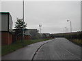
Wigwam Lane, Hucknall
By the industrial site, with the now standard mobile phone mast
Image: © Tom Courtney
Taken: 13 Aug 2005
0.04 miles
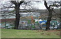
2

Small canalised stream at Butler's Hill
Passing between industrial units. It joins the river Leen in a few hundred metres.
On the left is the base of a mobile phone mast.
Image: © David Lally
Taken: 27 Apr 2017
0.06 miles
4
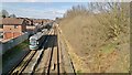
NET tram and Robin Hood line heading north at Butler's Hill
Image: © Chris Morgan
Taken: 10 Mar 2014
0.15 miles
5
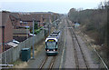
Tram approaching Butlers Hill
The right hand track is the Nottingham to Mansfield Railway, which was singled to provide space for the tram. The original intention was to have mixed tram and rail operation on the principle developed by Nottingham's twin city Karlsruhe, but it turned out to be impracticable to meet the requirements of the railway authorities.
Image: © Alan Murray-Rust
Taken: 13 Jan 2008
0.17 miles
6
Hucknall recycling centre
Alongside an industrial estate built on the site of a former brickworks
Image: © Alan Murray-Rust
Taken: 13 Jan 2008
0.18 miles
7
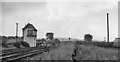
Site of Butler's Hill Station
View southward, towards Nottingham (Victoria) and Colwick Yard etc.; ex-Great Northern Leen Valley line, Nottingham and Netherfield & Colwick - Shirebrook. The station closed to passengers when the service was withdrawn on 14/9/31, but coal traffic still ran over this stretch until 1968. There is now a 'Butler's Hill' tram-stop near here on the Nottingham Express Transit system.
Image: © Ben Brooksbank
Taken: 12 Jul 1963
0.20 miles
8
Butler's Hill railway station (site), Nottinghamshire
Opened in 1882 by the Great Northern Railway on the line from Nottingham (Victoria) and Colwick to Shirebrook, this station closed to passengers in 1931. The site was eventually redeveloped for housing.
View south east towards Bestwood Colliery and Nottingham from a similar position to Image] taken some 53 years earlier. The Robin Hood railway line and NET tram tracks are behind the houses to the left and Butler's Hill tram stop is just beyond the houses in the distance.
Image: © Nigel Thompson
Taken: 11 Jan 2016
0.20 miles
9
Footpath to Hucknall
A long-standing right of way between Bestwood Village and Hucknall, seen from the railway bridge of the disused railway line to Calverton Colliery
Image: © Alan Murray-Rust
Taken: 13 Jan 2008
0.21 miles
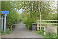
10
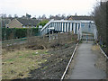
Footbridge at Butlers Hill
This spans the Nottingham to Mansfield railway (Robin Hood Line) and the tram to Hucknall (NET)
Image: © Alan Murray-Rust
Taken: 13 Jan 2008
0.21 miles