IMAGES TAKEN NEAR TO
North Sherwood Street, NOTTINGHAM, NG1 4EN
Introduction
This page details the photographs taken nearby to North Sherwood Street, NG1 4EN by members of the Geograph project.
The Geograph project started in 2005 with the aim of publishing, organising and preserving representative images for every square kilometre of Great Britain, Ireland and the Isle of Man.

There are currently over 7.5m images from over14,400 individuals and you can help contribute to the project by visiting https://www.geograph.org.uk
Image Map
Images are licensed for reuse under creativecommons.org/licenses/by-sa/2.0
Notes
- Clicking on the map will re-center to the selected point.
- The higher the marker number, the further away the image location is from the centre of the postcode.
Image Listing (344 Images Found)
Images are licensed for reuse under creativecommons.org/licenses/by-sa/2.0
Image
Details
Distance
2
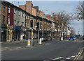
Top of Mansfield Road
Mansfield Road carries on for several miles beyond the crest visible, but this is the summit coming out of the City centre and the description would be well understood locally.
One of a series showing different building styles on Mansfield Road. See http://www.geograph.org.uk/search.php?i=5550541
Image: © Alan Murray-Rust
Taken: 8 Mar 2009
0.01 miles
3
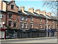
A fine array of pots
Many of the buildings on Mnasfield Road have lost their traditional chimney stacks and pots on modernisation, but this group retains a fine display.
One of a series showing different building styles on Mansfield Road. See http://www.geograph.org.uk/search.php?i=5550541
Image: © Alan Murray-Rust
Taken: 8 Mar 2009
0.01 miles
4
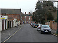
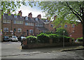
Villa Road
Looking towards Mansfield Road. This is the opposite direction to Image and there is a stark contrast between the type of housing at the opposite ends.
Image: © Alan Murray-Rust
Taken: 8 Mar 2009
0.01 miles
5
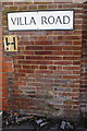
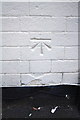
Benchmark on #192 Mansfield Road (Villa Road face)
The Ordnance Survey cut mark benchmark, which is on the 6th and 7th brick courses above ground below the A of Villa, is described on the Bench Mark Database at http://www.bench-marks.org.uk/bm47854
Image: © Roger Templeman
Taken: 31 Mar 2013
0.01 miles
6
Behind Mansfield Road
A view from North Sherwood Street, taken on a May morning. The long rows of windows below the eaves show that these houses on Mansfield Road once housed framework knitters, whose workshops needed good lighting.
Image: © John Sutton
Taken: 12 May 2018
0.02 miles
7
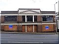
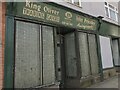
Just sold
Formerly the home of auctioneers Neals of Nottingham, the mixed use building of over 20,000 square feet was recently (October 2016) sold to the Church of England for £1.3 million.
Image: © Michael Dibb
Taken: 31 Mar 2017
0.02 miles
8
Junction of Villa Road and Mansfield Road
There is an OS benchmark Image on the wall on the right hand side of Villa Road under the road name sign left of the No Entry sign
Image: © Roger Templeman
Taken: 31 Mar 2013
0.02 miles
9
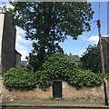
Gate to a disused Jewish Cemetery
In use from 1823 until 1869, the cemetery is situated in a courtyard hidden behind a stone wall, on the East side of North Sherwood Street, about 30 yards from the junction with Forest Road East.. The burial records are lost and only about 15 stones are extant. The cemetery belonged to the Nottingham Municipality but was purchased outright by the Community in 1946. The Cemetery is locked and the keys are held by the Nottingham Hebrew Congregation. Source; David Shulman, Webmaster JCR-UK [September 2016].
Image: © David Lally
Taken: 7 Jun 2023
0.02 miles
10
Benchmark on #252 North Sherwood Road
Ordnance Survey cut mark benchmark described on the Bench Mark Database at http://www.bench-marks.org.uk/bm47853
Image: © Roger Templeman
Taken: 30 Mar 2013
0.02 miles