IMAGES TAKEN NEAR TO
Squirrel Way, NG14 6TD
Introduction
This page details the photographs taken nearby to Squirrel Way, NG14 6TD by members of the Geograph project.
The Geograph project started in 2005 with the aim of publishing, organising and preserving representative images for every square kilometre of Great Britain, Ireland and the Isle of Man.

There are currently over 7.5m images from over14,400 individuals and you can help contribute to the project by visiting https://www.geograph.org.uk
Image Map
Images are licensed for reuse under creativecommons.org/licenses/by-sa/2.0
Notes
- Clicking on the map will re-center to the selected point.
- The higher the marker number, the further away the image location is from the centre of the postcode.
Image Listing (36 Images Found)
Images are licensed for reuse under creativecommons.org/licenses/by-sa/2.0
Image
Details
Distance
1
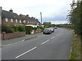
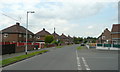
Park Road
The western leg of this road which forms the perimeter of the expansion of Calverton as a colliery village in the 1950s.
Image: © Alan Murray-Rust
Taken: 14 Aug 2011
0.05 miles
2
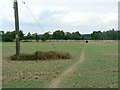
Field footpath near Calverton
Not a formal right of way, but clearly well used for all that.
Image: © Alan Murray-Rust
Taken: 14 Aug 2011
0.10 miles
3
Forest Road
Part of the western block of development of Calverton as a colliery village in the 1950s.
Image: © Alan Murray-Rust
Taken: 14 Aug 2011
0.10 miles
4
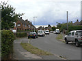
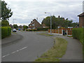
Seely Avenue, Calverton
The north end of Seely Avenue, seen from its junction with Park Road on a misty November morning.
Image: © Richard Vince
Taken: 24 Nov 2012
0.10 miles
5
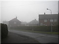
Forest Road, Calverton
Mining village housing at the junction of Ramsdale Avenue.
Part of a Local Authority housing estate developed between 1953 and 1954 by Basford Rural District Council.
Image: © Jonathan Billinger
Taken: 16 Jun 2008
0.12 miles
6
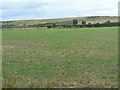
Landscape near Calverton
Now more rural than it used to be - the high ground in the background is the landscaped spoilheap of the former Calverton Colliery.
Image: © Alan Murray-Rust
Taken: 14 Aug 2011
0.13 miles
7
Seely Avenue
Part of the western block of development of Calverton as a colliery village in the 1950s.
Image: © Alan Murray-Rust
Taken: 14 Aug 2011
0.13 miles
8
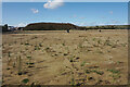
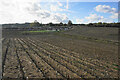
Land earmarked for housing
This will be further north west expansion of Calverton.
Image: © Bill Boaden
Taken: 15 Oct 2022
0.14 miles
9
Stubble field near Calverton
A former crop of sweetcorn. Beyond the field is the north west expansion of housing in Calverton.
Image: © Bill Boaden
Taken: 15 Oct 2022
0.14 miles
10
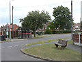
Collyer Road at Lee Road
The design of bench seat with the large baulk of timber at the back of the seat seems to be a specific local variant.
Image: © Alan Murray-Rust
Taken: 14 Aug 2011
0.15 miles