IMAGES TAKEN NEAR TO
Seely Avenue, NOTTINGHAM, NG14 6NF
Introduction
This page details the photographs taken nearby to Seely Avenue, NG14 6NF by members of the Geograph project.
The Geograph project started in 2005 with the aim of publishing, organising and preserving representative images for every square kilometre of Great Britain, Ireland and the Isle of Man.

There are currently over 7.5m images from over14,400 individuals and you can help contribute to the project by visiting https://www.geograph.org.uk
Image Map
Images are licensed for reuse under creativecommons.org/licenses/by-sa/2.0
Notes
- Clicking on the map will re-center to the selected point.
- The higher the marker number, the further away the image location is from the centre of the postcode.
Image Listing (41 Images Found)
Images are licensed for reuse under creativecommons.org/licenses/by-sa/2.0
Image
Details
Distance
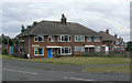
1
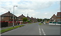
Seely Avenue
Part of the western block of development of Calverton as a colliery village in the 1950s.
Image: © Alan Murray-Rust
Taken: 14 Aug 2011
0.07 miles
2
Sherwood Avenue
Part of the western block of development of Calverton as a colliery village in the 1950s and 60s, built by the National Coal Board.
Image: © Alan Murray-Rust
Taken: 14 Aug 2011
0.08 miles
3
Forest Road
Part of the western block of development of Calverton as a colliery village in the 1950s.
Image: © Alan Murray-Rust
Taken: 14 Aug 2011
0.09 miles
4
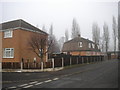
Houses on Collyer Road
Part of the western block of development of Calverton as a colliery village in the 1950s. These examples appear to be more substantial than most, with a double-front appearance. However the side door gives the game away - these are in fact maisonettes, each confined to a single storey.
Image: © Alan Murray-Rust
Taken: 14 Aug 2011
0.09 miles
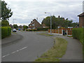
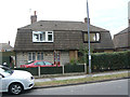
5
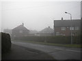
Seely Avenue, Calverton
The north end of Seely Avenue, seen from its junction with Park Road on a misty November morning.
Image: © Richard Vince
Taken: 24 Nov 2012
0.09 miles
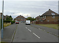
6
Forest Road, Calverton
Mining village housing at the junction of Ramsdale Avenue.
Part of a Local Authority housing estate developed between 1953 and 1954 by Basford Rural District Council.
Image: © Jonathan Billinger
Taken: 16 Jun 2008
0.10 miles
7
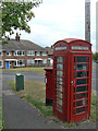
K6 kiosk and Collyer Road, Calverton postbox ref. NG14 105
One of two postboxes with the same name on Collyer Road. Although many K6 kiosks are listed, this one is not.
Image: © Alan Murray-Rust
Taken: 14 Aug 2011
0.11 miles
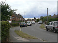
8
North end of Labray Road, Calverton
Contrasting domestic architecture at the north end of Labray Road. The trees (poplars?) in the background line the north side of Park Road, at the southern boundary of, appropriately, a park.
Image: © Richard Vince
Taken: 24 Nov 2012
0.11 miles
9
House on Park Road
This uses a different prefabrication system to the one shown in http://www.geograph.org.uk/photo/2558852. Here the upper storey framework is clad with hung tiles. The right hand house of the pair has been re-clad with brick at some stage, as have most of its fellows, leaving this as one of the few original examples. Prefabricated houses were extensively used by the National Coal Board in the post war era of colliery development.
Image: © Alan Murray-Rust
Taken: 14 Aug 2011
0.12 miles
10
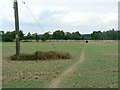
Field footpath near Calverton
Not a formal right of way, but clearly well used for all that.
Image: © Alan Murray-Rust
Taken: 14 Aug 2011
0.12 miles