IMAGES TAKEN NEAR TO
Epperstone, NOTTINGHAM, NG14 6AP
Introduction
This page details the photographs taken nearby to NG14 6AP by members of the Geograph project.
The Geograph project started in 2005 with the aim of publishing, organising and preserving representative images for every square kilometre of Great Britain, Ireland and the Isle of Man.

There are currently over 7.5m images from over14,400 individuals and you can help contribute to the project by visiting https://www.geograph.org.uk
Image Map
Images are licensed for reuse under creativecommons.org/licenses/by-sa/2.0
Notes
- Clicking on the map will re-center to the selected point.
- The higher the marker number, the further away the image location is from the centre of the postcode.
Image Listing (9 Images Found)
Images are licensed for reuse under creativecommons.org/licenses/by-sa/2.0
Image
Details
Distance
1
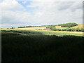
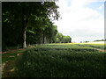
Park Farm seen from the shadow of Epperstone Park
The farmer has created and maintains a permissive path as an alternate route to the existing Epperstone to Oxton footpath. It broadly follows the edge of Epperstone Park and the farmer describes it as "the scenic route". It does indeed give good views across the valley of the Order Beck and has the advantage (for the farmer at least) of avoiding Park Farm.
Image: © Jonathan Thacker
Taken: 15 Jul 2022
0.01 miles
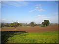
2
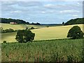
Rolling landscape
Park Farm lies hidden in the folds of the landscape with just the top of a barn showing.
Image: © Alan Murray-Rust
Taken: 12 Jul 2020
0.03 miles
3
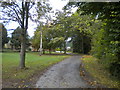
Eastern access to Park Farm
This track from just north of Epperstone also carries a public footpath.
Image: © Richard Vince
Taken: 9 Oct 2014
0.03 miles
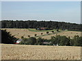
4
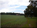
Field south of Park Farm
Looking towards the north end of Epperstone Park.
Image: © Richard Vince
Taken: 9 Oct 2014
0.04 miles
5

Track to Park Farm
A commendably well surfaced track that hosts a public footpath. The public right of way continues through the middle of the farmyard, but as I neared the buildings a very intimidating siren sounded; however, there were no signs to indicate that the right of way no longer existed.
Image: © Richard Vince
Taken: 9 Oct 2014
0.07 miles
6
Permissive path alongside Epperstone Park
The farmer has created and maintains a permissive path as an alternate route to the existing Epperstone to Oxton footpath. It broadly follows the edge of Epperstone Park and the farmer describes it as "the scenic route". It does indeed give good views across the valley of the Order Beck and has the advantage (for the farmer at least) of avoiding Park Farm.
Image: © Jonathan Thacker
Taken: 15 Jul 2022
0.17 miles
7
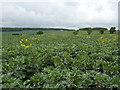
Broad beans, Epperstone
Farmland north of Epperstone; Park Farm is in the dip between the bean field and the house on the slope.
Image: © Peter Barr
Taken: 26 May 2011
0.19 miles
9
Park Farm
From the public Footpath nearby
Image: © Tom Courtney
Taken: 21 Aug 2005
0.24 miles