IMAGES TAKEN NEAR TO
St. Marys Close, NOTTINGHAM, NG13 0DR
Introduction
This page details the photographs taken nearby to St. Marys Close, NG13 0DR by members of the Geograph project.
The Geograph project started in 2005 with the aim of publishing, organising and preserving representative images for every square kilometre of Great Britain, Ireland and the Isle of Man.

There are currently over 7.5m images from over14,400 individuals and you can help contribute to the project by visiting https://www.geograph.org.uk
Image Map
Images are licensed for reuse under creativecommons.org/licenses/by-sa/2.0
Notes
- Clicking on the map will re-center to the selected point.
- The higher the marker number, the further away the image location is from the centre of the postcode.
Image Listing (259 Images Found)
Images are licensed for reuse under creativecommons.org/licenses/by-sa/2.0
Image
Details
Distance
1
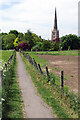
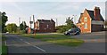
Bottesford - footpath from Station Road to church
Contrast Ben Brooksbank's 1963 photo Image
Image: © Dave Bevis
Taken: 15 Jun 2011
0.03 miles
2
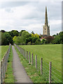
Path through Bottesford
The path connects the station with the centre of the village. St Mary's church overlooks the scene.
Image: © Stephen McKay
Taken: 17 May 2022
0.04 miles
4
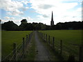
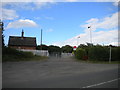
Footpath to church, Bottesford
From Station Road.
Image: © Richard Vince
Taken: 24 Jun 2017
0.05 miles
5
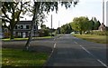
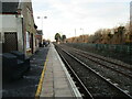
Bottesford Railway Station
Unsurprisingly located along Station Road.
Image: © Mat Fascione
Taken: 12 Oct 2008
0.08 miles
6

Footpath and train
The train is an East Midlands Trains service from Liverpool to Norwich.
Image: © Jonathan Thacker
Taken: 10 Apr 2012
0.08 miles
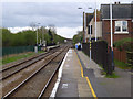
7
Bottesford Station
Bottesford Station has staggered platforms. This platform is raised part way along its length.
Image: © Jonathan Thacker
Taken: 27 Dec 2020
0.09 miles
8
Manually operated level crossing, Bottesford
Where a farm track and public bridleway cross the Nottingham to Grantham railway line immediately west of Bottesford station.
Image: © Richard Vince
Taken: 24 Jun 2017
0.09 miles
9
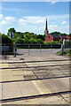
Bottesford Level Crossing
Situated just to the west of Bottesford station, this crossing provides access to a bridleway leading up Beacon Hill. The railway between Grantham and Nottingham is busy and vehicles are required to contact the signaller by telephone before proceeding. In the background is the spire of St Mary's Church.
Image: © Stephen McKay
Taken: 17 May 2022
0.09 miles
10
Bottesford Station
Looking east. The original low platforms have raised sections to allow for easy access into trains.
Image: © Alan Murray-Rust
Taken: 6 Apr 2014
0.09 miles