IMAGES TAKEN NEAR TO
Victor Crescent, NOTTINGHAM, NG10 5JS
Introduction
This page details the photographs taken nearby to Victor Crescent, NG10 5JS by members of the Geograph project.
The Geograph project started in 2005 with the aim of publishing, organising and preserving representative images for every square kilometre of Great Britain, Ireland and the Isle of Man.

There are currently over 7.5m images from over14,400 individuals and you can help contribute to the project by visiting https://www.geograph.org.uk
Image Map
Images are licensed for reuse under creativecommons.org/licenses/by-sa/2.0
Notes
- Clicking on the map will re-center to the selected point.
- The higher the marker number, the further away the image location is from the centre of the postcode.
Image Listing (102 Images Found)
Images are licensed for reuse under creativecommons.org/licenses/by-sa/2.0
Image
Details
Distance
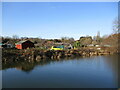
1
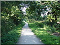
Part of the Derby and Sandiacre Canal
Most of this canal has disappeared, including this section immediately after the junction of the canal with the Erewash canal [http://www.geograph.org.uk/photo/891877]. This short stretch has been filled in and is now a cycle and footpath leading down to Longmoor Lane, about 0.5 km away. The other side of Longmoor Lane the canal has disappeared completely under an housing estate.
Image: © Oxymoron
Taken: 21 Jul 2008
0.06 miles
2
Path of Derby and Sandiacre Canal
Behind is the stub from the Erewash Canal which still contains water. Forward about 200 yards ahead is a rise in the path which looks like it marks where there was a lock (a rise of about 4 feet), then the next feature is the bridge where the canal passed under Longmoor Road Image
Image: © David Lally
Taken: 7 Jul 2008
0.07 miles
3
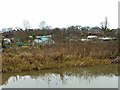
Allotments, Long Eaton
Alongside the Erewash Canal.
Image: © Alan Murray-Rust
Taken: 1 Jan 2018
0.08 miles
4
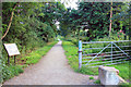
Former Derby Canal Recreational Route, Sandiacre Lock Area
This path heads off into the distance along the route of the most easterly segment of the former Derby Canal. In the 1960s the canal was sealed off beneath the Lock Lane humped-backed bridge immediately behind the photographer. It was subsequently drained and filled-in to create a recreational activity route. The Derby Canal's former "Sandiacre Bottom Lock" was located beneath the photographer's feet, whereas the former "Sandiacre Top Lock" is now buried 100 yards ahead. A farmhouse existed on the left-hand side between these former lock locations that became licensed as "The Boat Inn" in 1845. It was apparently 'closed-up' in 1940 when it was destroyed by fire.
Image: © David Hallam-Jones
Taken: 17 Feb 2013
0.08 miles
5
Allotments beyond the canal
Looking across the Erewash Canal.
Image: © Jonathan Thacker
Taken: 26 Jan 2022
0.08 miles
6
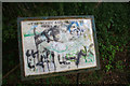
Badly Defaced Information Board
An information board at the start of the path which follows the filled Derby and Sandiacre Canal.
It would have been useful to study the section which shows the map of the former route, but it is illegable.
Image: © David Lally
Taken: 7 Jul 2008
0.10 miles
7
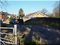
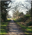
Sandiacre Lock Vicinity, Derbys.
This rider is moving away from Lock Lane bridge and is 2-3 minutes ride from Longmoor Road (the B6002 road) along Lock Lane. The bridleway, footpath and cycle route reached via the gate on the left runs along the route of the most easterly segment of the former Derby Canal. The canal was sealed beneath this bridge and drained and filled in during the 1960s. Almost immediately behind the photographer is the closed end (the cul-de-sac) of Lock Lane, behind the Sandiacre Lock Cottages.
Image: © David Hallam-Jones
Taken: 17 Feb 2013
0.10 miles
8
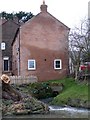
House on Lock Lane
The end wall seems very damp, perhaps because the lock by-wash flows underneath.
Image: © Christine Johnstone
Taken: 24 Jan 2010
0.10 miles
9
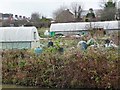
Allotments lying between the Erewash and disused Derby canals
These are very big allotment 'sheds'
Image: © Christine Johnstone
Taken: 24 Jan 2010
0.10 miles
10
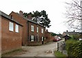
Beech House, Sandiacre Lock
Late 18th century house, Listed Grade II. The location suggests that the owner could have been linked with the local canals.
Image: © Alan Murray-Rust
Taken: 1 Jan 2018
0.10 miles