IMAGES TAKEN NEAR TO
Tynedale Close, NOTTINGHAM, NG10 3PT
Introduction
This page details the photographs taken nearby to Tynedale Close, NG10 3PT by members of the Geograph project.
The Geograph project started in 2005 with the aim of publishing, organising and preserving representative images for every square kilometre of Great Britain, Ireland and the Isle of Man.

There are currently over 7.5m images from over14,400 individuals and you can help contribute to the project by visiting https://www.geograph.org.uk
Image Map
Images are licensed for reuse under creativecommons.org/licenses/by-sa/2.0
Notes
- Clicking on the map will re-center to the selected point.
- The higher the marker number, the further away the image location is from the centre of the postcode.
Image Listing (12 Images Found)
Images are licensed for reuse under creativecommons.org/licenses/by-sa/2.0
Image
Details
Distance
1
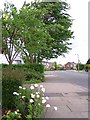
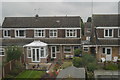
Ruskin Avenue
In the 1940s there were a number of roads only about 100 yards long, off Wilsthorpe Road. Since then the M1 motorway has been constructed to the west and in the latter half of the last century those short roads were extended and linked resulting in a large housing estate now filling the intervening area. Trees and flowers in the gardens are now softening the landscape and giving the estate a more mature feel.
Image: © Garth Newton
Taken: 18 May 2006
0.13 miles
2
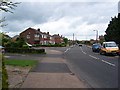
Ruskin Avenue/Ribblesdale Road junction
This shows the main spine of the estate that was the first to be developed in the latter half of the 20th century. Newer properties have since been built off Ribblesdale Road to the left.
Image: © Garth Newton
Taken: 18 May 2006
0.17 miles

4
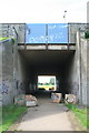
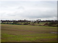
Subway Under M1
From the suburban estates of Long Eaton into the fields of Breaston Fields Farm (the farmhouse can be seen in the distance).
Image: © David Lally
Taken: 8 Jul 2008
0.18 miles
5
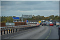
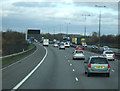
Erewash : M1 Motorway
The M1 Motorway between Junction 24A and Junction 25 (Sandiacre).
Image: © Lewis Clarke
Taken: 30 Sep 2018
0.19 miles
7

Graffitied Tunnel Entrance Under The M1
Leading into the outskirts of Long Eaton, From Breaston Fields Farm.
Image: © David Lally
Taken: 8 Jul 2008
0.21 miles
9
M1 Motorway Crossing Burton-Nottingham Railway Line
Image: © Roy Hughes
Taken: 16 Mar 2013
0.22 miles
10
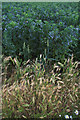
Evidence of Previous Crops
The field is growing field beans, but on the margin both wheat and barley plants grow.
Image: © David Lally
Taken: 8 Jul 2008
0.23 miles