IMAGES TAKEN NEAR TO
Clarence Road, NOTTINGHAM, NG10 3NQ
Introduction
This page details the photographs taken nearby to Clarence Road, NG10 3NQ by members of the Geograph project.
The Geograph project started in 2005 with the aim of publishing, organising and preserving representative images for every square kilometre of Great Britain, Ireland and the Isle of Man.

There are currently over 7.5m images from over14,400 individuals and you can help contribute to the project by visiting https://www.geograph.org.uk
Image Map
Images are licensed for reuse under creativecommons.org/licenses/by-sa/2.0
Notes
- Clicking on the map will re-center to the selected point.
- The higher the marker number, the further away the image location is from the centre of the postcode.
Image Listing (82 Images Found)
Images are licensed for reuse under creativecommons.org/licenses/by-sa/2.0
Image
Details
Distance
1
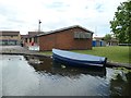
RN 94, 15th Long Eaton Sea Scouts and Guides
Land access from Clarence Road, water access from the Erewash Canal.
Image: © Christine Johnstone
Taken: 6 May 2019
0.02 miles
2
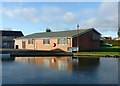
15th Long Eaton Sea Scouts and Guides
Having to make do with the confined waters of the Erewash Canal rather than the open sea.
Image: © Alan Murray-Rust
Taken: 1 Jan 2018
0.02 miles
3
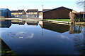
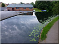
Long Eaton Sea Scouts hut
This group may be housed far from the sea, but they do have navigable water nearby. They used to have a boat moored here, but in that last year or so that seems to have been disposed of.
Image: © David Lally
Taken: 10 Feb 2008
0.02 miles
5
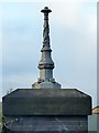
Inscription and cast iron lamp base, Tamworth Road canal bridge
See http://www.geograph.org.uk/photo/5643503 for location.
Image: © Alan Murray-Rust
Taken: 1 Jan 2018
0.04 miles
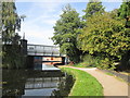
6
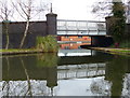
Long Eaton Bridge on the Erewash Canal
Carrying the B6540 Tamworth Road across the canal.
Image: © Mat Fascione
Taken: 28 Feb 2016
0.04 miles
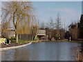
7
Tamworth Road canal bridge
The canal is widened to allow long boats to take an easy sweep of the bend. The grassed patch to the left of the bridge started life as a coal wharf; how things have changed!
Image: © Alan Murray-Rust
Taken: 1 Jan 2018
0.04 miles
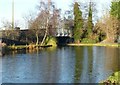
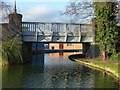
8
Erewash Canal
This bridge carries the B6540 over the Erewash Canal
Image: © Tim Glover
Taken: 17 Jan 1999
0.04 miles
9
Tamworth Road Bridge over the Erewash Canal
Image: © John Slater
Taken: 24 Sep 2013
0.04 miles
10
Tamworth Road canal bridge on the Erewash Canal
Built in 1911 http://www.geograph.org.uk/photo/5643551 when the road was widened. See http://www.geograph.org.uk/photo/5643499 for a detail of the parapet.
Image: © Alan Murray-Rust
Taken: 1 Jan 2018
0.04 miles