IMAGES TAKEN NEAR TO
Near Meadow, NOTTINGHAM, NG10 1PZ
Introduction
This page details the photographs taken nearby to Near Meadow, NG10 1PZ by members of the Geograph project.
The Geograph project started in 2005 with the aim of publishing, organising and preserving representative images for every square kilometre of Great Britain, Ireland and the Isle of Man.

There are currently over 7.5m images from over14,400 individuals and you can help contribute to the project by visiting https://www.geograph.org.uk
Image Map
Images are licensed for reuse under creativecommons.org/licenses/by-sa/2.0
Notes
- Clicking on the map will re-center to the selected point.
- The higher the marker number, the further away the image location is from the centre of the postcode.
Image Listing (13 Images Found)
Images are licensed for reuse under creativecommons.org/licenses/by-sa/2.0
Image
Details
Distance
1
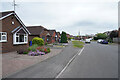
Bosworth Way
Looking along the bungalows of Bosworth Way towards the distant power station at Ratcliffe on Soar.
Image: © Malcolm Neal
Taken: 17 Jun 2021
0.08 miles
2
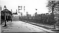
A Down empties from the Derby/Burton direction passes Trent Station South Box
View SW from the south end of Trent Station; ex-Midland major junction of the London - Leicester - Sheffield and Derby etc. - Nottingham main trunk lines. The Junction remains a focal point of trunk lines, but Trent Station itself served little purpose for passengers except to change trains and was closed on 1/1/68. The Class F empties is no doubt bound for Toton Yard a mile or two to the north and probably came off the line from Burton-on-Trent via Castle Donington: it is headed by Stanier 8F 2-8-0 No. 48559.
Image: © Ben Brooksbank
Taken: 4 May 1965
0.17 miles
3
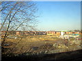
New House Site by Stanton Estates, Long Eaton
Image: © Roy Hughes
Taken: 2 Mar 2013
0.19 miles
4
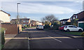
Fosbrooke Drive, Long Eaton
Off Bosworth Way.
Image: © Robin Stott
Taken: 18 Nov 2017
0.20 miles
5
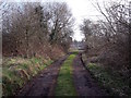
Old railway curve at Forbes Hole
This access track used to be part of the railway, most of which is now under Fields Farm Road.
Image: © Ian Calderwood
Taken: 11 Mar 2016
0.20 miles
6
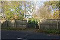
A way through the fence on the north side of Fields Farm Road, Long Eaton
A boarded fence screens Fields Farm Road from residential areas and open space to the north. From the west, this is the first gap for about 600 metres. It leads to a pleasant walk.
Image: © Robin Stott
Taken: 18 Nov 2017
0.21 miles
7
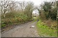
Network Rail access track
To the tracks at Trent Junction (behind the photographer) skirting the edge of the Forbe's Hole Local Nature Reserve,
Image: © David Lally
Taken: 9 Dec 2020
0.21 miles
9
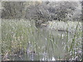
Forbes Hole local nature reserve
The reeds in Forbes hole reserve
Image: © Peter Shone
Taken: 18 Sep 2005
0.24 miles
10
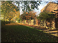
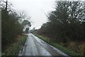
Wide walk south of Meynell Road and Wyvern Avenue, Long Eaton
The foreground and distant shadow is cast by the fence that screens Fields Farm Road.
Image: © Robin Stott
Taken: 18 Nov 2017
0.24 miles