IMAGES TAKEN NEAR TO
Quorndon Crescent, NOTTINGHAM, NG10 1AL
Introduction
This page details the photographs taken nearby to Quorndon Crescent, NG10 1AL by members of the Geograph project.
The Geograph project started in 2005 with the aim of publishing, organising and preserving representative images for every square kilometre of Great Britain, Ireland and the Isle of Man.

There are currently over 7.5m images from over14,400 individuals and you can help contribute to the project by visiting https://www.geograph.org.uk
Image Map
Images are licensed for reuse under creativecommons.org/licenses/by-sa/2.0
Notes
- Clicking on the map will re-center to the selected point.
- The higher the marker number, the further away the image location is from the centre of the postcode.
Image Listing (75 Images Found)
Images are licensed for reuse under creativecommons.org/licenses/by-sa/2.0
Image
Details
Distance
1
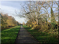
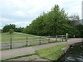
Open space parallel to Fields Farm Road, Long Eaton
The road runs behind a long fence among the trees, left. Barker's Pond is through the trees, right. The tree with the pale bark is an Ash; it's dead. The path leads to the Erewash Canal.
Image: © Robin Stott
Taken: 18 Nov 2017
0.04 miles
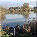
2
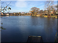
Looking northwest across Barker's Pond, Long Eaton
Wyvern Avenue, right, overlooks this fishing lake. I saw at least one angler in place on this sunny November morning. Old maps show it as Fish Pond, later just Pond. Only streetmap.co.uk calls it Barkers Pond but I'm following Ian Calderwood in giving it an apostrophe: Image
Image: © Robin Stott
Taken: 18 Nov 2017
0.05 miles
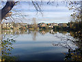
3
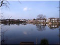
Barker's Pond
Barker's Pond has been a fish pond since at least the 1880s and pre-dates everything round about it.
Image: © Ian Calderwood
Taken: 11 Mar 2016
0.05 miles
4
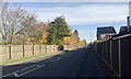
East on Fields Farm Road, Long Eaton
East of the Erewash Canal bridge and approaching the Bosworth Way turn.
Image: © Robin Stott
Taken: 18 Nov 2017
0.07 miles
5

Lodge Road and postbox NG10 37D, Long Eaton
Image: © Robin Stott
Taken: 18 Nov 2017
0.07 miles
6
Oak tree by Barker's Pond, Long Eaton
The houses are in Wyvern Avenue. There are several fishing pegs around the pond – and at least one fisherman on this sunny November morning.
Image: © Robin Stott
Taken: 18 Nov 2017
0.07 miles
7
Path heading east from the Erewash Canal
On the north side of, and parallel to, Fields Farm Road.
Image: © Christine Johnstone
Taken: 6 May 2019
0.09 miles
8
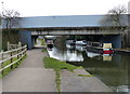
Fields Farm Road Bridge and the Erewash Canal
Image: © Mat Fascione
Taken: 28 Feb 2016
0.09 miles
9
Wyvern Avenue and Meynell Road seen across Barker's Pond, Long Eaton
Image: © Robin Stott
Taken: 18 Nov 2017
0.10 miles
10
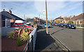
Northwest on Wyvern Avenue, Long Eaton
As seen elsewhere, a mix of bungalows and two-storey houses. The concrete lamp post was leaning, not the photographer.
Image: © Robin Stott
Taken: 18 Nov 2017
0.10 miles