IMAGES TAKEN NEAR TO
Clayport Mews, Clayport Street, ALNWICK, NE66 1LB
Introduction
This page details the photographs taken nearby to Clayport Mews, Clayport Street, NE66 1LB by members of the Geograph project.
The Geograph project started in 2005 with the aim of publishing, organising and preserving representative images for every square kilometre of Great Britain, Ireland and the Isle of Man.

There are currently over 7.5m images from over14,400 individuals and you can help contribute to the project by visiting https://www.geograph.org.uk
Image Map (421 Images)


Getting Data...Please wait
Leaflet Map data © OpenStreetMap
Images are licensed for reuse under creativecommons.org/licenses/by-sa/2.0
Notes
- Clicking on the map will re-center to the selected point.
- The higher the marker number, the further away the image location is from the centre of the postcode.
Image Listing (421 Images Found)
Images are licensed for reuse under creativecommons.org/licenses/by-sa/2.0
Image
Details
Distance
1
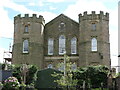
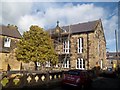
Sheraton House, Clayport Square, Alnwick
Set back from the street and 'Clayport Square' this Grade II Listed Building was built in 1846 as indicated within the foiled oculus in the central gable. The Sheraton House facia obscures the former inscription of 'United Presbyterian Church'.
Image: © Geoff Holland
Taken: 24 May 2021
0.01 miles
2
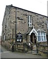
Methodist Church, Chapel Lane, Alnwick
Erected in 1786, and subsequently restored in 1886 this is a Grade II Listed Building. This fine south facing elevation contains a small central gable with a cross above and a foiled tablet bearing the dates of erection and restoration.
Image: © Geoff Holland
Taken: 24 May 2021
0.02 miles
3
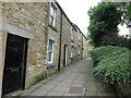
Dodds Lane, Alnwick
This narrow lane runs from Clayport Street and emerges eventually onto Green Batt.
Image: © Geoff Holland
Taken: 7 Jun 2021
0.02 miles
4
Methodist chapel
The chapel is in Chapel Lane and houses a pulpit which is said to be the original pulpit from which John Wesley preached in 1748.
Image: © Michael Dibb
Taken: 24 May 2011
0.02 miles
5
Alnwick Methodist Church
Alnwick Methodist Church in Chapel Lane was built in 1786 and remodelled 100 years later by F.R Wilson.
Methodism in North Northumberland began in Alnwick with the work of a local preacher who established a society. The Wesleys themselves arrived on a preaching tour in 1748, and had a long and happy relationship with Alnwick Methodists.
In 1786 John Wesley laid the foundation stone of a new chapel - still in use today.
http://www.lindisfarnemethodistchurches.org.uk/Alnwick.html
Image: © Russel Wills
Taken: 11 Jun 2012
0.02 miles
6
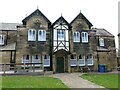
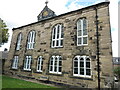
Wesley House, Chapel Lane, Alnwick
The founder of the Methodist movement, John Wesley, laid the first stone of Wesley House, and its adjoining chapel https://www.geograph.org.uk/photo/6847848, in 1786. A century later it was extensively remodelled and extended by the acclaimed local-based architect Frederick Richard Wilson, at that time Diocesan Surveyor for Lindisfarne, to create this rather imposing building. These days, the building offers self-catering holiday accommodation.
Image: © Geoff Holland
Taken: 24 May 2021
0.03 miles
7
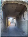
Chapel Lane
Seen from Market Street is the passage way to Chapel Lane. The Methodist Chapel can be glimpsed.
Image: © Michael Dibb
Taken: 22 May 2011
0.03 miles
9
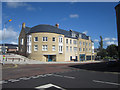
New residential and retail development, Alnwick
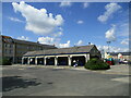
This new development in Alnwick town centre includes retail space on the ground floor (much of it still unlet 12 months after the buildings completion) and a large number of flats on the upper floors.
Image: © Graham Robson
Taken: 28 Aug 2012
0.04 miles