IMAGES TAKEN NEAR TO
Longhorsley, MORPETH, NE65 8UX
Introduction
This page details the photographs taken nearby to NE65 8UX by members of the Geograph project.
The Geograph project started in 2005 with the aim of publishing, organising and preserving representative images for every square kilometre of Great Britain, Ireland and the Isle of Man.

There are currently over 7.5m images from over14,400 individuals and you can help contribute to the project by visiting https://www.geograph.org.uk
Image Map
Images are licensed for reuse under creativecommons.org/licenses/by-sa/2.0
Notes
- Clicking on the map will re-center to the selected point.
- The higher the marker number, the further away the image location is from the centre of the postcode.
Image Listing (60 Images Found)
Images are licensed for reuse under creativecommons.org/licenses/by-sa/2.0
Image
Details
Distance
1
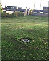
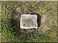
Fundamental Benchmark
These Ordnance Survey benchmarks, of which there are only 200 in the UK, are the cornerstones of the countrywide height measurement network, the mean sea level reference point being the Newlyn Datum in Cornwall. Unlike the more familiar trig points, they are still in use and are regularly checked. The concrete block is set on bedrock for stability. The height is specified as 124.0106 metres. Such precision! See closeup Image For full details see https://www.bench-marks.org.uk/bm1108
Image: © Leanmeanmo
Taken: 29 Oct 2021
0.02 miles
2
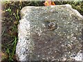
Fundamental Benchmark
The benchmark is damaged but the hemispherical brass bolt head still looks serviceable. See also Image For more details see https://www.bench-marks.org.uk/bm1108
Image: © Leanmeanmo
Taken: 29 Oct 2021
0.04 miles
3
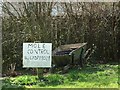
Save the Mole!
Spotted on the grass verge on the main road through Longhorsley!
Image: © Christine Westerback
Taken: 14 Apr 2006
0.04 miles
4
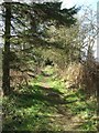
Footpath
A footpath running alongside the A697 through Longhorlsey. The footpath is very short but I spotted 15 different bird species.
Image: © Christine Westerback
Taken: 14 Apr 2006
0.04 miles
5
Longhorsley Fundamental Benchmark
On the village green in Longhorsley, Longhorsley Fundamental Benchmark is marked by a brass bolt set in an irregular granite block at ground level (location photograph Image). It was levelled in 1918 and marks a height of 124.0106m above Ordnance Datum Newlyn. It is in use as an Ordnance Survey passive GPS station.
Image: © Adrian Taylor
Taken: 29 Jul 2022
0.04 miles
6

Farm Cat
Marmalade sentinel, Longhorsley, Northumberland
Image: © Christine Westerback
Taken: 17 Feb 2008
0.05 miles
7

Horsley Tower
An ancient battlemented Peel tower
Image: © Stuart Shepherd
Taken: 29 Jul 2015
0.06 miles
8

Cottages in Longhorsley
The cottages are opposite the village green and face onto West Road.
The rectangular granite block set into the village green is the Longhorsley Fundamental Benchmark (photograph Image).
Image: © Adrian Taylor
Taken: 29 Jul 2022
0.06 miles
9
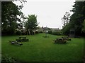
Play park, Longhorsley
A small park with picnic benches and swings close to the centre of Longhorsley.
Image: © Graham Robson
Taken: 3 Jun 2018
0.06 miles
10
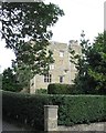
Horsley Tower
According to Pevsner's guide to the buildings of Northumberland, this is a sixteenth century tower offering some protection from Scottish raiders. The third floor was used as a RC chapel in the late 18th and early 19th centuries, whilst the tower was restored in 1930. Now a private residence.
Image: © Gordon Hatton
Taken: 15 Aug 2018
0.08 miles