IMAGES TAKEN NEAR TO
MORPETH, NE61 2YR
Introduction
This page details the photographs taken nearby to NE61 2YR by members of the Geograph project.
The Geograph project started in 2005 with the aim of publishing, organising and preserving representative images for every square kilometre of Great Britain, Ireland and the Isle of Man.

There are currently over 7.5m images from over14,400 individuals and you can help contribute to the project by visiting https://www.geograph.org.uk
Image Map (15 Images)


Getting Data...Please wait
Leaflet Map data © OpenStreetMap
Images are licensed for reuse under creativecommons.org/licenses/by-sa/2.0
Notes
- Clicking on the map will re-center to the selected point.
- The higher the marker number, the further away the image location is from the centre of the postcode.
Image Listing (15 Images Found)
Images are licensed for reuse under creativecommons.org/licenses/by-sa/2.0
Image
Details
Distance
1
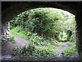
The Wanney Line
The old trackbed of the Wanney railway line which ran between Morpeth and Scotsgap, now overgrown with the encroaching woodland. The line finally closed in September 1966.
Image: © Antonia
Taken: 16 Jul 2007
0.08 miles
2
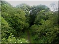
Bridleway on former railway alignment
Looking from a bridge down onto a bridleway which follows a former railway alignment to the south of Morpeth.
Image: © Graham Robson
Taken: 3 Jul 2016
0.09 miles
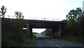
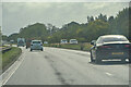
5
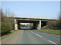
A1 bridge over the B6524
Heading north east towards Morpeth.
Image: © JThomas
Taken: 9 Apr 2015
0.13 miles
6
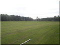
Morpeth "Common"
Common Grazing land that once formed part of Morpeth Common still retains the name, but has been given over to purposes other than grazing. The 1940s maps show it as a rifle range, but during World War Two it was used to house Polish refugees, who still maintain a strong presence in the locality. It was also used as a hospital, before being turned into its current use - a rugby pitch (the football ground lies just off shot to the right).
Image: © Iain McDonald
Taken: 20 Sep 2005
0.16 miles
7
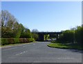
B6524 passes under the A1
By the Piramal factory.
Image: © Russel Wills
Taken: 27 Apr 2015
0.18 miles
8
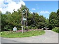
Entrance to Craik Park
Craik Park is the home of Morpeth Football Club. It adjoins an extensive are of public open space (informally known as Morpeth Common) which is managed by Morpeth Town Council.
Image: © Oliver Dixon
Taken: 13 Jul 2011
0.19 miles

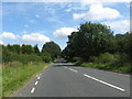
10
Mitford : A1
Heading south on the A1.
Image: © Lewis Clarke
Taken: 25 Sep 2020
0.24 miles