IMAGES TAKEN NEAR TO
NE61 2GY
Introduction
This page details the photographs taken nearby to NE61 2GY by members of the Geograph project.
The Geograph project started in 2005 with the aim of publishing, organising and preserving representative images for every square kilometre of Great Britain, Ireland and the Isle of Man.

There are currently over 7.5m images from over14,400 individuals and you can help contribute to the project by visiting https://www.geograph.org.uk
Image Map
Images are licensed for reuse under creativecommons.org/licenses/by-sa/2.0
Notes
- Clicking on the map will re-center to the selected point.
- The higher the marker number, the further away the image location is from the centre of the postcode.
Image Listing (14 Images Found)
Images are licensed for reuse under creativecommons.org/licenses/by-sa/2.0
Image
Details
Distance
1
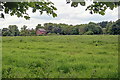
East Cottingwood
The name of a field formerly part of St Georges Hospital now managed by the Houses and Communities Agency so presumably earmarked for housing development.
The Houses and Communities Agency is a government agency but the "Private" signs are very intimidating for publicly owned land.
Image: © Mick Garratt
Taken: 1 Jun 2014
0.09 miles
3
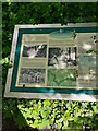
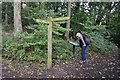
Information board in the woods
As always I am grateful to the many people behind these info boards, bringing the past to life for a rookie visitor like me.
Image: © Jeremy Bolwell
Taken: 3 Jun 2022
0.16 miles
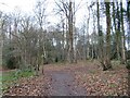
4
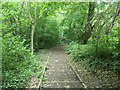
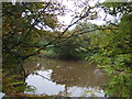
Steps in Bluebell Wood
A public footpath east of Morpeth and on the north side of the River Wansbeck.
Image: © Christine Johnstone
Taken: 18 Jul 2023
0.17 miles
5
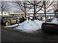
Morrison's car-park, Morpeth
Snow still lying in piles throughout the car-park making walking very difficult.
Image: © Willie Duffin
Taken: 24 Dec 2010
0.17 miles
6
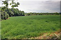
Pestilence Close
In this field victims of the 1665 plague are supposed to have been buried.
Image: © Mick Garratt
Taken: 1 Jun 2014
0.21 miles
8
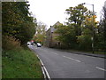
Path junction near Morpeth
The riverside path to Bothal keeps right and the left-hand route is to Cottingwood.
Image: © Jim Barton
Taken: 28 Sep 2017
0.22 miles
10
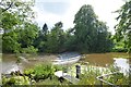
Weir near Morpeth
A weir on the River Wansbeck viewed from the A197.
Image: © DS Pugh
Taken: 4 Jul 2015
0.23 miles