IMAGES TAKEN NEAR TO
Langley-on-Tyne, HEXHAM, NE47 5LT
Introduction
This page details the photographs taken nearby to NE47 5LT by members of the Geograph project.
The Geograph project started in 2005 with the aim of publishing, organising and preserving representative images for every square kilometre of Great Britain, Ireland and the Isle of Man.

There are currently over 7.5m images from over14,400 individuals and you can help contribute to the project by visiting https://www.geograph.org.uk
Image Map
Images are licensed for reuse under creativecommons.org/licenses/by-sa/2.0
Notes
- Clicking on the map will re-center to the selected point.
- The higher the marker number, the further away the image location is from the centre of the postcode.
Image Listing (47 Images Found)
Images are licensed for reuse under creativecommons.org/licenses/by-sa/2.0
Image
Details
Distance
1
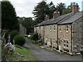
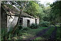
Sawmill Cottages (north-east range), Langley
A range of buildings here is shown on the first edition OS 6" scale map (published in 1865). However, it is not part of the scheduled area of the Langley & Blagill Lead Smelt Mills. The cottages remain occupied and have been greatly improved or rebuilt.
https://historicengland.org.uk/listing/the-list/list-entry/1018211?section=official-list-entry
Image: © Andrew Curtis
Taken: 15 Sep 2022
0.00 miles

4
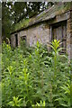
Sawmill Cottages (south-west range), Langley
"The building range known as Sawmill Cottages, which includes a two storey house at the east end of a row of three cottages, is excluded from the scheduling, although the ground beneath it and the flue which exits the building through the south wall are included. The 1805 plan of Blagill Mill shows this range of buildings to be the reducing and refining house. Across the trackway to the west of the cottage conversions there is another range of buildings, mostly surviving as wall footings with the easternmost single storey lean-to building still roofed and used as a garage. This building range is considered to have comprised ancillary buildings (such as store-rooms and workshops) and will retain buried deposits that will allow the identification of their functions."
https://historicengland.org.uk/listing/the-list/list-entry/1018211?section=official-list-entry
Allen Valleys Local History Group have a photo of these buildings taken in 1905: http://www.allenvalleyslocalhistory.org.uk/photo/langley-1905-0025-014/ https://web.archive.org/web/20220917110225/http://www.allenvalleyslocalhistory.org.uk/photo/langley-1905-0025-014/
Image: © Andrew Curtis
Taken: 15 Sep 2022
0.03 miles
5
Remaining building of Langley & Blaghill Lead Smelt Mills
Two-storey rear of ruined building shown here Image
Image: © Andrew Curtis
Taken: 15 Sep 2022
0.04 miles
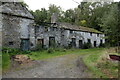
6
Remaining building of Langley & Blaghill Lead Smelt Mills
The two-storey rear elevation of this building is shown here Image
"One nearly complete building survives at the east end of the area, 60m east of Sawmill Cottages, which has been interpreted as a coal and lime house dating to before 1805. This twin celled, two storey stone building built into the rising ground, retains some flooring and more than half of its stone slab roofing. Across the trackway behind this building there is the approximately 2m high earthwork dam for the reservoir (which still holds water). This reservoir was part of a complex water management system which supplied water to both mills."
https://historicengland.org.uk/listing/the-list/list-entry/1018211?section=official-list-entry
Image: © Andrew Curtis
Taken: 15 Sep 2022
0.04 miles
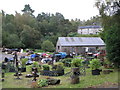
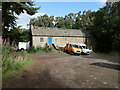
7
Lead Miner's Cottage
This rural land between Hexham and Allendale was an active lead mining area in the 19th century. This derelict cottage is believed to have been a miner's residence and is close to what is now a private fishing lake.
Image: © Charlie Bell
Taken: 12 Jul 2008
0.04 miles
10
Building north-west of Langley Garden Station
This building at the west end of the eastern reservoir is shown on the 25 inch scale Ordnance Survey map published in 1897 and is a surviving building from Langley & Blagill Lead Smelt Mills.
Keys to the Past (N13736) describes:
"This early 19th century building was the former store and office of the Langley Lead Smelting Mill. It is the only standing building left from this once extensive complex. This is a Grade II Listed Building protected by law."
https://keystothepast.info/search-records/results-of-search/results-of-search-2/Site-Details/?PRN=N13736 https://web.archive.org/web/20220917064854/https://keystothepast.info/search-records/results-of-search/results-of-search-2/Site-Details/?PRN=N13736
Beamish Museum's People's Collection have an undated photo of this building here: http://collections.beamish.org.uk/search-detail?item=NEG1846&query=langley&searchType=everything&hiQuality=0&withPhotos=1&filterQuery=smelt https://web.archive.org/web/20220917115836/http://collections.beamish.org.uk/search-detail?item=NEG1846&query=langley&searchType=everything&hiQuality=0&withPhotos=1&filterQuery=smelt
Langley and Blagill lead smeltmills, flue and chimney (Scheduled Monument)
https://historicengland.org.uk/listing/the-list/list-entry/1018211?section=official-list-entry
Image: © Andrew Curtis
Taken: 15 Sep 2022
0.07 miles