IMAGES TAKEN NEAR TO
Waterville Road, NORTH SHIELDS, NE29 6BL
Introduction
This page details the photographs taken nearby to Waterville Road, NE29 6BL by members of the Geograph project.
The Geograph project started in 2005 with the aim of publishing, organising and preserving representative images for every square kilometre of Great Britain, Ireland and the Isle of Man.

There are currently over 7.5m images from over14,400 individuals and you can help contribute to the project by visiting https://www.geograph.org.uk
Image Map
Images are licensed for reuse under creativecommons.org/licenses/by-sa/2.0
Notes
- Clicking on the map will re-center to the selected point.
- The higher the marker number, the further away the image location is from the centre of the postcode.
Image Listing (23 Images Found)
Images are licensed for reuse under creativecommons.org/licenses/by-sa/2.0
Image
Details
Distance
1
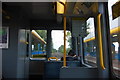
Interior of Metro carriage, looking towards the front
The best seat on the Metro is the one right at the front and next to the driver - this section (just arriving at Meadow Well station) is very straight
Image: © hayley green
Taken: 31 Aug 2009
0.11 miles
2
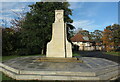
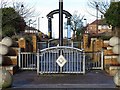
Smith's Dock Company War Memorial, Minton Lane, North Shields
Unveiled in 1922, the Memorial was erected by the Smith's Dock Company in memory of the employees from all departments who gave their lives in the Great War. It stands in a slightly different position to its original one, having been moved in order to facilitate the nearby housing development, although still in a park environment. It is a Grade II Listed building. For a selection of detailed free to download walking routes in the area visit www.northtynesidewalks.co.uk
Image: © Geoff Holland
Taken: 30 Oct 2020
0.13 miles
4
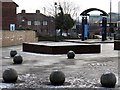
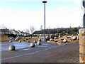
Square off Ripley Avenue, Meadow Well
"The first thing that strikes me is the quantity of concrete balls left lying round like a giants been out playing marbles..."
Joan Armstrong - a week in Meadow Well (2006) http://www.bbc.co.uk/tyne/content/articles/2006/09/12/meadowell_diary_feature.shtml
Steps below the iron sculpture go down to a large semi-circular square on Waterville Road providing the centre-piece of the semi-circular crescent of Avon Avenue Image
Image: © Andrew Curtis
Taken: 18 Jan 2018
0.16 miles
5
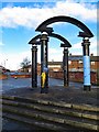
Forgotten sculpture in Meadow Well
I have been unable to find out the name or designer of these arched metal columns in the concrete square of Waterville Road Image
Image: © Andrew Curtis
Taken: 18 Jan 2018
0.16 miles
7
Steps to nameless square north of Waterville Road, Meadow Well
Formerly the junction (cross-roads) of Ripley Avenue with Waterville Road but now pedestrianised, hard-landscaped and rather bleak. The semi-circular structure of this part of the estate had been laid out by 1937 although the street names are different; for example, Ripley Avenue seems to have been Bridges Road.
See here for other detail: Image, Image
Image: © Andrew Curtis
Taken: 18 Jan 2018
0.16 miles
8
Nameless Square, Waterville Road
The square is really a circle centred on the former junction of Ripley Avenue (northern part now pedestrianised) and Waterville Road. It looks like a roundabout on Google Satellite view, with a paving design of contrasting colours forming an interlocking design. However, the west-east traffic on Waterville Road passes directly through its centre. To the north (shown), there is a semi-circular, paved square at road level with steps leading up to Ripley Road North Image through another hard-landscaped area with an arched sculpture Image
It appears to have been laid out in part of its current form by 1937. If it has a name or any other history then I have been unable to find it.
"A five-year plan drawn up in 1930 projected the construction of 850 new council homes. In 1932, the Council purchased a 135 acre greenfield site on the north-western fringes of North Shields from the Duke of Northumberland. This was to be the Ridges Estate – the original name of Meadow Well and one by which it is still sometimes known.
The new estate contained 1961 homes. Forty of these were old people’s bungalows, 268 were self-contained houses and 1653 (84 per cent) were so-called Tyneside flats, common in the area – two-storeyed dwellings with flats top and bottom and separate ground-floor front doors, built in blocks of four.
In practice, the layout of the Estate paid some tribute to the earlier superior cottage suburbs in its ‘Garden City’-style crescents and cul-de-sacs and it represented a good home to its new residents."
However, Meadow Well became the classic ‘problem estate’, and centre for riots in 1991 https://en.wikipedia.org/wiki/Meadow_Well_riots
The reasons why are discussed in the links below:
Municipal Dreams: https://municipaldreams.wordpress.com/2016/02/16/the-meadow-well-estate-north-shields-i/ https://municipaldreams.wordpress.com/2016/02/23/the-meadow-well-estate-north-shields-ii/
Recent research (28/01/2018) has at last reveealed the name of this square.
'Central Focus', a hard landscaping project by Brambledown Landscape Services Ltd. for North Tyneside Council:
"Redevelopment of the Meadowell area of North Shields. The levels and walls create an amphitheatre effect, while the ‘Celtic Knot’ paving is a distinctive and unique feature. This project won a BALI National Landscape award for Hard Landscaping."
Image: © Andrew Curtis
Taken: 18 Jan 2018
0.16 miles
9
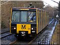
Metro train approaching Meadow Well Station
"Metro increasingly adopted the black 'M' as its logo, and it soon came to adorn the front and sides of the Metrocars. The Calvert typeface, and in particular the black 'M' on yellow background, became as locally distinctive markers of the Metro as the London Underground roundel is for Londoners. Outside Metro stations, you’ll now find totems with a yellow box at the top, each vertical side displaying a Calvert 'M' Image
"M is for… Metro" - Calvert typeface and the Nexus Tyne and Wear public transport visual identity: https://thebeautyoftransport.com/2017/04/19/m-is-for-metro-calvert-typeface-and-the-nexus-tyne-and-wear-public-transport-visual-identity/
Image: © Andrew Curtis
Taken: 18 Jan 2018
0.17 miles
10

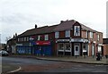
Graffiti, Urban Area, Smith's Park, North Shields
This is a close up of a section of the boundary wall shown at https://www.geograph.org.uk/photo/6659744. The boundary fencing of this basketball court at Smith's Park has had large boarding attached and this boarding is available for use, through a Phoenix Detached Youth Project/Pinkdot Productions partnership. The partnership aims to encourage urban artists, who would otherwise create anti-social artworks on the streets, to access legal space to paint. For a selection of detailed free to download walking routes in the area visit www.northtynesidewalks.co.uk
Image: © Geoff Holland
Taken: 30 Oct 2020
0.17 miles