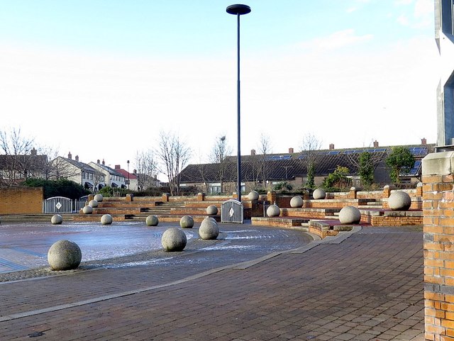
Nameless Square, Waterville Road
Introduction
The photograph on this page of Nameless Square, Waterville Road by Andrew Curtis as part of the Geograph project.
The Geograph project started in 2005 with the aim of publishing, organising and preserving representative images for every square kilometre of Great Britain, Ireland and the Isle of Man.
There are currently over 7.5m images from over 14,400 individuals and you can help contribute to the project by visiting https://www.geograph.org.uk

Image: © Andrew Curtis Taken: 18 Jan 2018
The square is really a circle centred on the former junction of Ripley Avenue (northern part now pedestrianised) and Waterville Road. It looks like a roundabout on Google Satellite view, with a paving design of contrasting colours forming an interlocking design. However, the west-east traffic on Waterville Road passes directly through its centre. To the north (shown), there is a semi-circular, paved square at road level with steps leading up to Ripley Road North Image through another hard-landscaped area with an arched sculpture Image It appears to have been laid out in part of its current form by 1937. If it has a name or any other history then I have been unable to find it. "A five-year plan drawn up in 1930 projected the construction of 850 new council homes. In 1932, the Council purchased a 135 acre greenfield site on the north-western fringes of North Shields from the Duke of Northumberland. This was to be the Ridges Estate – the original name of Meadow Well and one by which it is still sometimes known. The new estate contained 1961 homes. Forty of these were old people’s bungalows, 268 were self-contained houses and 1653 (84 per cent) were so-called Tyneside flats, common in the area – two-storeyed dwellings with flats top and bottom and separate ground-floor front doors, built in blocks of four. In practice, the layout of the Estate paid some tribute to the earlier superior cottage suburbs in its ‘Garden City’-style crescents and cul-de-sacs and it represented a good home to its new residents." However, Meadow Well became the classic ‘problem estate’, and centre for riots in 1991 https://en.wikipedia.org/wiki/Meadow_Well_riots The reasons why are discussed in the links below: Municipal Dreams: https://municipaldreams.wordpress.com/2016/02/16/the-meadow-well-estate-north-shields-i/ https://municipaldreams.wordpress.com/2016/02/23/the-meadow-well-estate-north-shields-ii/ Recent research (28/01/2018) has at last reveealed the name of this square. 'Central Focus', a hard landscaping project by Brambledown Landscape Services Ltd. for North Tyneside Council: "Redevelopment of the Meadowell area of North Shields. The levels and walls create an amphitheatre effect, while the ‘Celtic Knot’ paving is a distinctive and unique feature. This project won a BALI National Landscape award for Hard Landscaping."

