IMAGES TAKEN NEAR TO
Hillsden Road, WHITLEY BAY, NE25 9XF
Introduction
This page details the photographs taken nearby to Hillsden Road, NE25 9XF by members of the Geograph project.
The Geograph project started in 2005 with the aim of publishing, organising and preserving representative images for every square kilometre of Great Britain, Ireland and the Isle of Man.

There are currently over 7.5m images from over14,400 individuals and you can help contribute to the project by visiting https://www.geograph.org.uk
Image Map
Images are licensed for reuse under creativecommons.org/licenses/by-sa/2.0
Notes
- Clicking on the map will re-center to the selected point.
- The higher the marker number, the further away the image location is from the centre of the postcode.
Image Listing (9 Images Found)
Images are licensed for reuse under creativecommons.org/licenses/by-sa/2.0
Image
Details
Distance
1
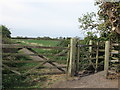
Kissing Gate at Beaumont Park Housing Estate, Whitley Bay
This kissing gate gives access to and egress from the public footpath shown at https://www.geograph.org.uk/photo/6443194, which links Beaumont Park housing estate with the course of the old Avenue Branch of the Blyth & Tyne Railway, now designated as a 'traffic-free cycle route'. For a selection of detailed free to download walking routes in the area visit www.northtynesidewalks.co.uk
Image: © Geoff Holland
Taken: 14 Apr 2020
0.18 miles
2
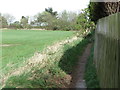
Footpath adjoining Beaumont Park Housing Estate, Whitley Bay
This footpath is not shown on the current Ordnance Survey 1:25K map of the area nor is it a designated public footpath. It extends from a point just next to the kissing gate shown at https://www.geograph.org.uk/photo/6443234 to the course of the old Avenue Branch of the Blyth & Tyne Railway, now designated as a 'traffic-free cycle route'. For a selection of detailed free to download walking routes in the area visit www.northtynesidewalks.co.uk
Image: © Geoff Holland
Taken: 14 Apr 2020
0.21 miles
3
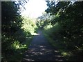
Bridleway between housing estates, Monkseaton
Looking along the route of a bridleway which passes along a former railway alignment between housing estates in Monkseaton.
Image: © Graham Robson
Taken: 29 Aug 2016
0.22 miles
4
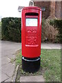
Post Box, Beaumont Drive, Whitley Bay
This Type K post box, which stands on Beaumont Drive next to the junction with Cranleigh Place, dates from the reign of Queen Elizabeth and was probably erected in the early 1970s. For a selection of detailed free to download walking routes in the area visit www.northtynesidewalks.co.uk
Image: © Geoff Holland
Taken: 12 Mar 2021
0.22 miles
5
Waggonways
The former Avenue Branch of the Blyth and Tyne Railway, now a cycle track and footpath.
Image: © Mick Garratt
Taken: 3 May 2015
0.23 miles
6
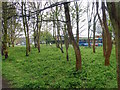
Public Woodland adjacent to the Waggonways
Image: © Mick Garratt
Taken: 3 May 2015
0.23 miles
7
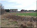
Urban fringe
Houses on Beaumont Drive, Whitley Bay, backing onto open fields.
Image: © Oliver Dixon
Taken: 23 Feb 2012
0.23 miles
8
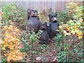
'The Three Bears' Wood Carving, The Red House Ramble
This wood carving forms part of the Red House Ramble an urban community project between three housing estates with a log and chipping footpath meandering through copses, a community orchard and grassed areas. The project is committed to biodiversity and to shaping the landscape environmentally. It received the Queen's Award for Voluntary Service in 2020. For a selection of detailed free to download walking routes in the area visit www.northtynesidewalks.co.uk
Image: © Geoff Holland
Taken: 27 Oct 2020
0.23 miles
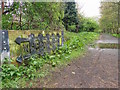
9
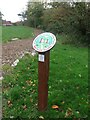
Signage, The Red House Ramble
The Red House Ramble is an urban community project between three housing estates with a log and chipping footpath meandering through copses, a community orchard and grassed areas. The project is committed to biodiversity and to shaping the landscape environmentally. It received the Queen's Award for Voluntary Service in 2020. For a selection of detailed free to download walking routes in the area visit www.northtynesidewalks.co.uk
Image: © Geoff Holland
Taken: 27 Oct 2020
0.24 miles