IMAGES TAKEN NEAR TO
Hatfield Drive, CRAMLINGTON, NE23 7TU
Introduction
This page details the photographs taken nearby to Hatfield Drive, NE23 7TU by members of the Geograph project.
The Geograph project started in 2005 with the aim of publishing, organising and preserving representative images for every square kilometre of Great Britain, Ireland and the Isle of Man.

There are currently over 7.5m images from over14,400 individuals and you can help contribute to the project by visiting https://www.geograph.org.uk
Image Map (Loading...)


Getting Data...Please wait
Leaflet Map data © OpenStreetMap
Images are licensed for reuse under creativecommons.org/licenses/by-sa/2.0
Notes
- Clicking on the map will re-center to the selected point.
- The higher the marker number, the further away the image location is from the centre of the postcode.
Image Listing (23 Images Found)
Images are licensed for reuse under creativecommons.org/licenses/by-sa/2.0
Image
Details
Distance
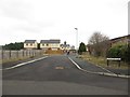
1
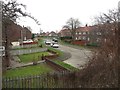
Blaketown, Seghill
A residential street close to the centre of the village.
Image: © Graham Robson
Taken: 13 Jan 2018
0.10 miles
2
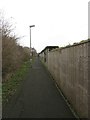
Footpath, Seghill
A footpath between housing estates in Seghill. The path is on an embankment above the level of the surrounding properties on the alignment of an old railway line which connected the nearby mineral railway to the East Coast Mainline.
Image: © Graham Robson
Taken: 13 Jan 2018
0.11 miles
4
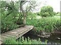
Footbridge Over the Seaton Burn Near Mare Close Farm, Seghill
This simple footbridge serves as a link between the housing estate on one side of the burn (south) and the various paths and tracks on the other side (north). Whilst a footbridge has existed in this location for more than 100 years, the footpaths on either side are not designated public footpaths although they are used by custom as such. For a selection of detailed free to download walking routes in the area visit www.northtynesidewalks.co.uk
Image: © Geoff Holland
Taken: 30 Jun 2020
0.14 miles
5
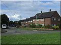
Kensington Close, Seghill
A development of half a dozen new houses on the edge of Seghill.
Image: © Graham Robson
Taken: 13 Jan 2018
0.15 miles
6
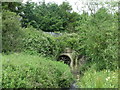
Culvert on the Seaton Burn, Seghill
This large culvert carries the Seaton Burn beneath a mineral railway line, a line which was formerly part of the Blyth & Tyne Railway. For a selection of detailed free to download walking routes in the area visit www.northtynesidewalks.co.uk
Image: © Geoff Holland
Taken: 30 Jun 2020
0.15 miles
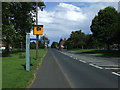
8
Level crossing, Station Road, Seghill
The level crossing where Station Road crosses a single track mineral railway in the eastern end of Seghill.
Image: © Graham Robson
Taken: 13 Jan 2018
0.16 miles
9
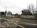
Mineral railway level crossing, Seghill
The mineral railway connecting Blyth and Lynemouth to the East Coast Mainline passing through Seghill.
Image: © Graham Robson
Taken: 13 Jan 2018
0.16 miles
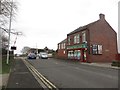
10
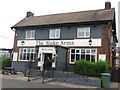
The Blake Arms, Seghill
This public house has undergone a bit of a makeover since Christine Westerback visited here back in 2005 https://www.geograph.org.uk/photo/36031. For a selection of detailed free to download walking routes in the area visit www.northtynesidewalks.co.uk
Image: © Geoff Holland
Taken: 30 Jun 2020
0.16 miles