IMAGES TAKEN NEAR TO
Olive Grove, CRAMLINGTON, NE23 7FH
Introduction
This page details the photographs taken nearby to Olive Grove, NE23 7FH by members of the Geograph project.
The Geograph project started in 2005 with the aim of publishing, organising and preserving representative images for every square kilometre of Great Britain, Ireland and the Isle of Man.

There are currently over 7.5m images from over14,400 individuals and you can help contribute to the project by visiting https://www.geograph.org.uk
Image Map
Images are licensed for reuse under creativecommons.org/licenses/by-sa/2.0
Notes
- Clicking on the map will re-center to the selected point.
- The higher the marker number, the further away the image location is from the centre of the postcode.
Image Listing (34 Images Found)
Images are licensed for reuse under creativecommons.org/licenses/by-sa/2.0
Image
Details
Distance
1
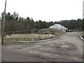
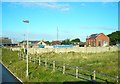
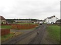
Olive Grove, Seghill
A housing development close to Middle Farm in Seghill. A few of the plots have occupied homes on them, however progress appears to be slow on the other spaces in the development.
Image: © Graham Robson
Taken: 13 Jan 2018
0.00 miles
2
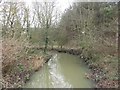
Seaton Burn, Seghill
The large stream flows through farmland to the north of the village. Seen here from the lane to Middle Farm which crosses the watercourse.
Image: © Graham Robson
Taken: 13 Jan 2018
0.02 miles
3
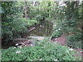
Sharp Bend In The Seaton Burn Near Middle Farm
At this point, the Seaton Burn makes a 90 degree turn in its course from a northerly direction to an easterly direction. As a consequence, a considerable amount of water borne woody debris, such as logs, sticks and branches, is likely to collect where the burn turns. For a selection of detailed free to download walking routes in the area visit www.northtynesidewalks.co.uk
Image: © Geoff Holland
Taken: 30 Jun 2020
0.04 miles
4
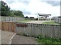
"Field of Dreams"
The fanciful title given to the playground adjoining the housing development at Middle Farm, Seghill.
Image: © Oliver Dixon
Taken: 20 Jul 2020
0.05 miles
5
Former Seghill Colliery pit yard
The mine closed in 1962. This is now a small industrial area. Some of the original pit buildings remain, supplemented by an assortment of more recent buildings.
The mine was mentioned in the old folk song 'Blackleg Miner':
'Dinna gang near the Seghill mine.
Across the way they stretch a line,
To catch the throat and break the spine
Of the dirty blackleg miner.'
Image: © Antony Dixon
Taken: 14 Sep 2012
0.06 miles
6
Middle Grange Farm
View East along the public footpath towards Middle Grange Farm, near Seghill/Seaton Delaval.
Image: © Ian Brackenridge
Taken: 24 Dec 2009
0.08 miles
7
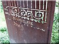
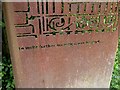
"The gates with their warning signs only served..."
Close-up of one leaf of the gates seen in Image See also Image Pity about the almost inevitable graffiti.
Image: © Oliver Dixon
Taken: 20 Jul 2020
0.09 miles
8
"...to invite further investigations beyond..."
Image: © Oliver Dixon
Taken: 20 Jul 2020
0.09 miles
9
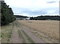
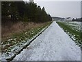
Bridleway to Middle Farm
The farmland to the north of Seghill is criss-crossed with bridleways, many of which coincide with the line of old waggonways. Middle Farm is a cluster of farm buildings which have been converted to a number of desirable residences.
Image: © Oliver Dixon
Taken: 20 Jul 2020
0.10 miles
10
Middle Farm, Seghill
A mixture of traditional stone cottages and converted farm buildings on the edge of Seghill.
Image: © Graham Robson
Taken: 13 Jan 2018
0.10 miles