IMAGES TAKEN NEAR TO
Mares Close, CRAMLINGTON, NE23 7ED
Introduction
This page details the photographs taken nearby to Mares Close, NE23 7ED by members of the Geograph project.
The Geograph project started in 2005 with the aim of publishing, organising and preserving representative images for every square kilometre of Great Britain, Ireland and the Isle of Man.

There are currently over 7.5m images from over14,400 individuals and you can help contribute to the project by visiting https://www.geograph.org.uk
Image Map
Images are licensed for reuse under creativecommons.org/licenses/by-sa/2.0
Notes
- Clicking on the map will re-center to the selected point.
- The higher the marker number, the further away the image location is from the centre of the postcode.
Image Listing (18 Images Found)
Images are licensed for reuse under creativecommons.org/licenses/by-sa/2.0
Image
Details
Distance
1

Moss on Stone Wall
Growing in profusion on stone wall, Mare Close, Seghill.
Image: © Christine Westerback
Taken: 8 Jan 2012
0.02 miles
2
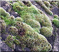
Moss Close-up
Moss comes in hundreds of varieties and is unlike other plants being without flowers or seeds but are made up of leaves which grow on tiny stems. They reproduce by spreading spores and absorb water. Moss is still used in certain parts of the world as a dressing and also nappies for babies. It often grows in soft spongy mounds.
Image: © Christine Westerback
Taken: 8 Jan 2012
0.04 miles
3
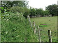
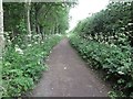
Footpath Near Mare Close Farm, Seghill
This footpath, which is not a designated public footpath, is used as a link between the housing estate to the south and the various paths and tracks to the north. It hugs the field boundary like a long-lost friend. For a selection of detailed free to download walking routes in the area visit www.northtynesidewalks.co.uk
Image: © Geoff Holland
Taken: 30 Jun 2020
0.05 miles
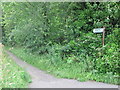
4
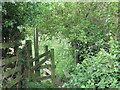
Path Entrance Near Mare Close Farm, Seghill
This is the extreme northern end of the footpath shown at https://www.geograph.org.uk/photo/6524285 and is relatively well hidden when approaching from Mare Close. For a selection of detailed free to download walking routes in the area visit www.northtynesidewalks.co.uk
Image: © Geoff Holland
Taken: 30 Jun 2020
0.06 miles
5
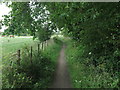
Public Footpath Near Holy Trinity Church, Seghill
This footpath connects the area around Holy Trinity Church and Mare Close Farm with the A192 road north west of Seaton Delaval. For a selection of detailed free to download walking routes in the area visit www.northtynesidewalks.co.uk
Image: © Geoff Holland
Taken: 7 Jul 2020
0.07 miles
6
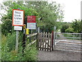
Signage At Railway Crossing Near Mare Close, Seghill
At this point the track, which has existed here for more than 170 years, crosses the mineral railway shown at https://www.geograph.org.uk/photo/6524298. As with all such crossings there is a plethora of warning notices. For a selection of detailed free to download walking routes in the area visit www.northtynesidewalks.co.uk
Image: © Geoff Holland
Taken: 30 Jun 2020
0.08 miles
7
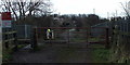
Unmanned Level Crossing, Seghill
This crossing separates the few houses at Mares Close, Seghill with many footpaths which lead to Cramlington and Seaton Delaval - taken on a dull day!
Image: © Christine Westerback
Taken: 8 Jan 2012
0.08 miles
8
Sign Near Holy Trinity Church, Seghill
This public footpath sign stands next to the boundary of Holy Trinity Church, and denotes a footpath which heads towards the A192 road as it passes through the north end of Seaton Delaval. For a selection of detailed free to download walking routes in the area visit www.northtynesidewalks.co.uk
Image: © Geoff Holland
Taken: 7 Jul 2020
0.08 miles
9
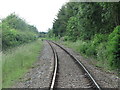
Mineral Railway Near Mare Close, Seghill
This mineral railway links Blyth and Lynemouth with the East Coast Main Line and was once part of the former Blyth & Tyne railway network. For a selection of detailed free to download walking routes in the area visit www.northtynesidewalks.co.uk
Image: © Geoff Holland
Taken: 30 Jun 2020
0.09 miles
10
Track Near Mare Close, Seghill
This track, whilst not shown on the Ordnance Survey map of the area as a designated public footpath or bridleway, it is most certainly used as such, and has existed in this location for more than 170 years. It is used as a recreational link between the Seaton Delaval to Seghill road (A190) and the spider's web of footpaths and tracks to the north and west. For a selection of detailed free to download walking routes in the area visit www.northtynesidewalks.co.uk
Image: © Geoff Holland
Taken: 30 Jun 2020
0.11 miles