IMAGES TAKEN NEAR TO
L'Arbre Crescent, NEWCASTLE UPON TYNE, NE16 5YG
Introduction
This page details the photographs taken nearby to L'Arbre Crescent, NE16 5YG by members of the Geograph project.
The Geograph project started in 2005 with the aim of publishing, organising and preserving representative images for every square kilometre of Great Britain, Ireland and the Isle of Man.

There are currently over 7.5m images from over14,400 individuals and you can help contribute to the project by visiting https://www.geograph.org.uk
Image Map
Images are licensed for reuse under creativecommons.org/licenses/by-sa/2.0
Notes
- Clicking on the map will re-center to the selected point.
- The higher the marker number, the further away the image location is from the centre of the postcode.
Image Listing (12 Images Found)
Images are licensed for reuse under creativecommons.org/licenses/by-sa/2.0
Image
Details
Distance
1
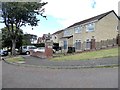
Parkdale Rise
Suburban street in Whickham. A less-than-authentic heraldic lion stands at the beginning of the street.
Image: © Oliver Dixon
Taken: 29 Jul 2020
0.08 miles
2
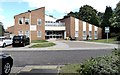
Castle Close
Retirement housing in Whickham.
Image: © Oliver Dixon
Taken: 29 Jul 2020
0.13 miles
4
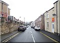
West Street, Whickham
Part of the older town centre. Some of these houses are probably late Victorian.
Image: © Robert Graham
Taken: 9 Nov 2016
0.20 miles
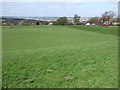
5
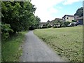
Woodhouses Lane and Ingleside
Woodhouses Lane is a stone-dust surfaced bridleway, popular with walkers, cyclists and horse-riders, which skirts the west side of Whickham.
Here if converges on Ingleside, one of the streets in the housing estate west of Fellside Road.
Image: © Oliver Dixon
Taken: 29 Jul 2020
0.21 miles
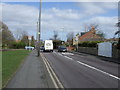
7
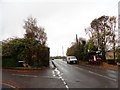
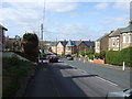
Junction of Runnymede and Fellside Roads
Looking south along Fellside Road. Whickham has extensive modern suburbs to the south of the old village centre.
Image: © Robert Graham
Taken: 9 Nov 2016
0.22 miles
8
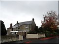
Old house on Runnymede Road, Whickham
This big old house is on the junction between Runnymede and Fellside Roads. It obviously is a lot older than the surrounding housing estates, and from a survey of old maps would appear to be late C19.
Image: © Robert Graham
Taken: 9 Nov 2016
0.23 miles
10
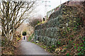
Woodhouses Lane descending
Woodhouses Lane contours around the eastern slope of the Derwent valley, bounding the limit of housing on the western side of Whickham; it then descends to reach Swalwell. The slope is a steep one at the camera location and rock-filled cages - gabions - have been used as stabilisation.
Image: © Trevor Littlewood
Taken: 1 Jan 2019
0.23 miles