IMAGES TAKEN NEAR TO
Military Road, NEWCASTLE UPON TYNE, NE15 0HA
Introduction
This page details the photographs taken nearby to Military Road, NE15 0HA by members of the Geograph project.
The Geograph project started in 2005 with the aim of publishing, organising and preserving representative images for every square kilometre of Great Britain, Ireland and the Isle of Man.

There are currently over 7.5m images from over14,400 individuals and you can help contribute to the project by visiting https://www.geograph.org.uk
Image Map
Images are licensed for reuse under creativecommons.org/licenses/by-sa/2.0
Notes
- Clicking on the map will re-center to the selected point.
- The higher the marker number, the further away the image location is from the centre of the postcode.
Image Listing (119 Images Found)
Images are licensed for reuse under creativecommons.org/licenses/by-sa/2.0
Image
Details
Distance
2
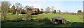
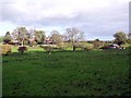
The Glebe Field, Heddon on the Wall
The houses behind are on the Military Road. The Roman Vallum runs across the field behind the small building.
Image: © Andrew Curtis
Taken: 27 Oct 2013
0.06 miles
3
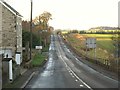
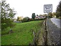
The Military Road (B6318), Heddon-on-the-Wall
The road lies on the line of Hadrian's Wall, with the north defensive ditch clearly visible on its right. Looking WNW along the line of the Wall towards the site of Turret 12a (Heddon West) at the top of the first rise. There is a "reverse" view (taken from beyond the speed restriction signs) in Image photographed by Oliver Dixon.
Image: © Mike Quinn
Taken: 22 Nov 2011
0.06 miles
4
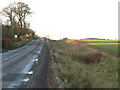
The north defensive ditch of Hadrian's Wall, Heddon-on-the-Wall
See Image Turret 12a (Heddon West) was near the top of the rise.
Image: © Mike Quinn
Taken: 22 Nov 2011
0.06 miles
6
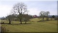
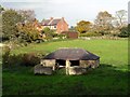
The Glebe Field, Heddon on the Wall
Hadrian's Wall lies under the tarmac of Wade's Military Road for many miles west of Heddon. The Vallum running alongside it to the south is visible as parallel banks on the right side of the photograph maintained by the absence of cultivation.
Image: © Andrew Curtis
Taken: 15 Jan 2009
0.07 miles
7
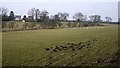
The Glebe Field, Heddon on the Wall
The houses are on the Military Road built on the foundations of the Roman Wall. The vallum russ parallel through the top of the field. The Inclosure Act of 1717 caused the Common Land of Heddon to be divided into four parts, the Glebe lands going to the Vicar.
Image: © Andrew Curtis
Taken: 15 Jan 2009
0.08 miles
9
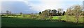
Hexham Road west of Heddon on the Wall
Image: © Andrew Curtis
Taken: 27 Oct 2013
0.10 miles
10
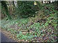
Site of former well, Haxham Road, Heddon on the Wall
The well is on the edge of the road. The former quarry is shrouded in trees behind.
Image: © Andrew Curtis
Taken: 27 Oct 2013
0.10 miles