IMAGES TAKEN NEAR TO
Ivy Farm Court, NEWCASTLE UPON TYNE, NE13 8AX
Introduction
This page details the photographs taken nearby to Ivy Farm Court, NE13 8AX by members of the Geograph project.
The Geograph project started in 2005 with the aim of publishing, organising and preserving representative images for every square kilometre of Great Britain, Ireland and the Isle of Man.

There are currently over 7.5m images from over14,400 individuals and you can help contribute to the project by visiting https://www.geograph.org.uk
Image Map
Images are licensed for reuse under creativecommons.org/licenses/by-sa/2.0
Notes
- Clicking on the map will re-center to the selected point.
- The higher the marker number, the further away the image location is from the centre of the postcode.
Image Listing (69 Images Found)
Images are licensed for reuse under creativecommons.org/licenses/by-sa/2.0
Image
Details
Distance
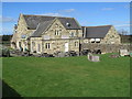
1
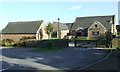
Twin Farms
A large rural pub with lots of outdoor seating and tables.
Image: © Thomas Nugent
Taken: 6 Oct 2008
0.02 miles
2
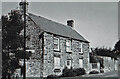
Brown's Buildings, Kenton Bank Foot
See the description in previous image Image Photograph not precisely dated but almost certainly late 1990s before being demolished for the building of the Twin Farms public house. The "Station" sign on the lamp-post is still in the same position indicating the precise location.
Image: © Phil Thirkell
Taken: Unknown
0.03 miles
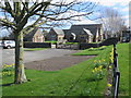
3
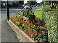
Flower bed on Main Road
With what appears to be a piece of old agricultural machinery as a centrepiece. At the junction with Brunton Road.
Image: © Thomas Nugent
Taken: 6 Oct 2008
0.03 miles
7
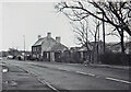
Brown's Buildings, Kenton Bank Foot
The following description is taken from A Guide to the Industrial Archaeology of Tyne & Wear, compiled by Ian Ayris & Stafford M Linsley (1994): "The dilapidated remains of a smithy which was formerly part of the early nineteenth century group of buildings at bank foot. Some details can still be discerned including the iron tyre ring inlaid in the smithy floor. A site unlikely to survive future development."
The photograph isn't precisely dated but was almost certainly taken in the late 1990s shortly before the buildings were demolished and the Twin Farms public house built on the site.
The lamp-post with a "Station" sign, and the bus stop, are still there indicating a precise location.
Image: © Phil Thirkell
Taken: Unknown
0.04 miles
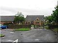
8
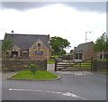
Twin Farms Public House
Building not shown on OS map, maybe due to it being a new build. A farm let alone 2 farms has never in recent memory been on this site. Just a breweries imagination I guess.
Image: © Newbiggin Hall Scouts
Taken: 27 May 2007
0.04 miles
9
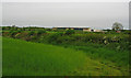
Arable Field, Kenton Bankfoot
View towards Kingston Park rugby stadium.
Image: © wfmillar
Taken: 27 May 2014
0.05 miles
10
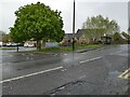
Twin Farms
Public house on Main Road, Kenton Bank Foot.
Image: © Oliver Dixon
Taken: 10 May 2023
0.05 miles