IMAGES TAKEN NEAR TO
Garth Twentyfour, NEWCASTLE UPON TYNE, NE12 6DH
Introduction
This page details the photographs taken nearby to Garth Twentyfour, NE12 6DH by members of the Geograph project.
The Geograph project started in 2005 with the aim of publishing, organising and preserving representative images for every square kilometre of Great Britain, Ireland and the Isle of Man.

There are currently over 7.5m images from over14,400 individuals and you can help contribute to the project by visiting https://www.geograph.org.uk
Image Map
Images are licensed for reuse under creativecommons.org/licenses/by-sa/2.0
Notes
- Clicking on the map will re-center to the selected point.
- The higher the marker number, the further away the image location is from the centre of the postcode.
Image Listing (10 Images Found)
Images are licensed for reuse under creativecommons.org/licenses/by-sa/2.0
Image
Details
Distance
1

Play area off East Bailey, Killingworth
Image: © Alex McGregor
Taken: 8 Jun 2011
0.21 miles
2

Small park. Killingworth
This small area of parkland separates Killingworth Village from Killingworth New Town
Image: © Chris Tweedy
Taken: 23 Jun 2004
0.21 miles
3

Kiddies play area.
Situated in a small area of parkland between Killingworth Village and Killingworth New Town.
Image: © Chris Tweedy
Taken: 23 Jun 2004
0.21 miles
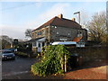
4
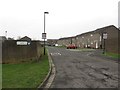
Garth Twenty, Killingworth
One of a number of residential streets leading off East Bailey in Killingworth.
Image: © Graham Robson
Taken: 13 Jan 2018
0.22 miles
5
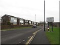
East Bailey, Killingworth
The street looping around the residential area to the east of the facilities in the centre of Killingworth.
Image: © Graham Robson
Taken: 13 Jan 2018
0.23 miles
6
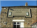
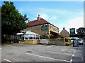
Signage, Killingworth Arms, Killingworth Village
The Killingworth Arms is one of two public houses serving this small village much as it was when the first edition of the Ordnance Survey Six-Inch map of the area was published in 1865. As the keen-eyed will note, from the sign, that this establishment was once known as the Killingworth Arms Hotel. For a selection of detailed free to download walking routes in the area visit www.northtynesidewalks.co.uk
Image: © Geoff Holland
Taken: 1 Dec 2020
0.24 miles
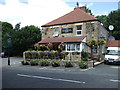
8
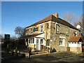
The Killingworth Arms, Killingworth Village
When the first edition of the Ordnance Survey Six-Inch map of the area was published in 1865, Killingworth Village was served by two public houses, the Killingworth Arms Hotel and the Plough Public House. Both still exist to this day although the Plough was rebuilt in 1910. Somewhere along the way the word 'Hotel' has been dropped from the name of this particular establishment https://www.geograph.org.uk/photo/6693412. For a selection of detailed free to download walking routes in the area visit www.northtynesidewalks.co.uk
Image: © Geoff Holland
Taken: 1 Dec 2020
0.24 miles